Small S'ly swell tomorrow, better activity from Sunday
Southern Tasmania Surf Forecast by Craig Brokensha (issued Wednesday 14th July)
Best Days: Tomorrow, Monday, early Tuesday
Features of the Forecast (tl;dr)
- Small S'ly swell tomorrow with mod-fresh N tending lighter NE winds
- Inconsistent W/SW groundswell building Sun with strong W/SW winds, easing Mon with N/NW tending N winds
- Good W/SW groundswell Tuesday with dawn NW tending strong SW winds
Recap
Tiny to flat surf yesterday and similar today.
This week and next (July 15 - 23)
Later today but more so tomorrow a small pulse of S-S/SE swell is due across Clifton, generated by a small, tight low that fired up south of us yesterday evening. Satellite observations are great and strong, but the low moved rapidly through our swell window, limiting the expected size.
A 1-2ft wave is likely most of tomorrow across Clifton, fading Friday. Winds will be favourable and moderate to fresh from the N/NE tending weaker NE tomorrow afternoon, N tending variable Friday.
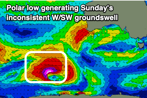
 Saturday will remain tiny, but our inconsistent W/SW groundswell from the polar low firing up east of Heard Island today is now looking a bit stronger and better. A great fetch of severe-gale to storm-force W/SW winds will be projected towards us this evening and tomorrow morning before the low breaks down.
The swell will be inconsistent but fill in Sunday, building to a great 2ft+ though the afternoon, with the possible 3ft set on dark, easing Monday from 2ft.
Winds on Sunday unfortunately look poor and strong from the W/SW-SW as the tail of a mid-latitude front clips us, cleaner Monday with N/NW tending N winds.
Following this polar low, we'll see another weaker system fire up, but closer to us, producing a good, reinforcing W/SW swell for very late Monday but more so Tuesday to 2-3ft across Clifton.
We may see a strong SW change on Tuesday, but we'll have a closer look at this in Friday's update.

