S/SE swell to make the most of
Southern Tasmania Surf Forecast by Craig Brokensha (issued Monday 28th June)
Best Days: Tomorrow, Wednesday, Thursday morning
Features of the Forecast (tl;dr)
- Easing S/SW swell tomorrow with moderate N tending variable NE winds
- Good, inconsistent S/SE groundswell for Wed with gusty N/NE winds, easing Thu with N winds
Recap
Clean, good waves on Saturday with the swell from Friday still coming in at 3ft, while yesterday continued around 2-3ft but with sloppier conditions.
Today our best S/SW swell has filled in with clean 3-4ft sets across Clifton. Conditions are still great with the swell now starting to ease.
This weekend and next week (Jun 26 – July 2)
Today's final pulse of S/SW swell is the last from a flurry of polar frontal activity last week and we'll see it easing fairly steadily from 2ft tomorrow morning with a N tending variable NE breeze.
 Our S/SE groundswell for Wednesday is on track and looking like making the most of as the outlook beyond it is fairly subdued.
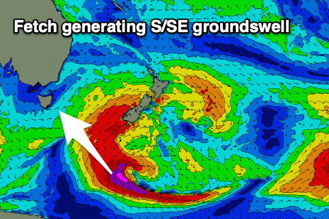
The source of this swell is the backside of the low generating today's swell, with a great fetch of severe-gale to storm-force S/SE winds being projected just on the edge of our swell window, south of New Zealand early this morning.
While inconsistent we should see strong 3ft sets across Clifton most of the day, bigger across more exposed spots down the South Arm and with a gusty N/NE breeze.
The swell will ease Thursday from an inconsistent 2ft+ as N'ly winds persist.
Following this, the storm track doesn't look favourable at all for any swell production of size for our region until late in the weekend/early next week. We may see a polar front generate a good S/SW groundswell but we'll have a closer look at this Wednesday.
In the meantime make the most of the current surf.

