Fading surf, more action from late week
Southern Tasmania Surf Forecast by Craig Brokensha (issued Monday 21st June)
Best Days: Beginners tomorrow, possibly Thursday, but more so Saturday through Tuesday next week
Features of the Forecast (tl;dr)
- Easing W/SW swell tomorrow with N/NW tending variable winds, tiny to flat Wed
- Small S/SW swell for Thu with N/NW winds ahead of a late SW change
- Good SW groundswell for Fri but with strong S/SE winds, easing and tending S/SW
- Building S/SW swell Sat with N/NW winds
- Possibly stronger SW groundswell Mon with NW winds
Recap
Bumpy, lumpy waves with a tiny swell Saturday, better yesterday with a new, building swell and offshore winds.
Today the swell is fun again, easing back from a clean, 2ft.
This week and weekend (Jun 22– 27)
The surf will remain clean over the coming days but fade in size as our pulses of W/SW groundswell ease. Tiny beginners waves due tomorrow, near flat into Wednesday.
A N/NW tending variable breeze is due tomorrow, N/NW-N all day Wednesday. Thursday will be clean most of the day ahead of a shallow, late SW change.
Come Thursday a new S/SW groundswell may be seen, much better and stronger from the SW Friday but we've still got those onshore winds due.
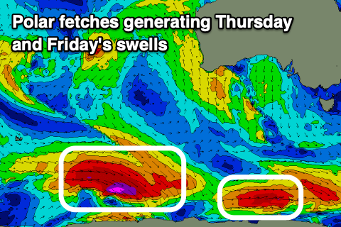
 The source of Friday's swell is a strong polar low that's fired up east of the Heard Island region, with a fetch of severe-gale W/NW tending W'ly winds due to provide a good kick in size to 3ft across Clifton. A slim fetch just ahead of it may generate 1-2ft of S/SW swell Thursday but this is a bit touch and go.
Unfortunately a trough will bring gusty S/SE winds on Friday, swinging S/SW into the afternoon and then likely back offshore Saturday morning as a high moves in from the west.
A new, reinforcing SW groundswell should fill in Saturday though, generated by a polar low firing up south-west of us Thursday. Saturday morning looks to be around 2ft+, with the new swell building to 2-3ft into the afternoon.
Following this, an even stronger polar low looks to generate a larger swell for Monday. Size wise this looks to come in around 3-4ft and with offshore winds likely, but we'll have a closer look at this Wednesday and Friday.

