Fun surf days from Sunday
Southern Tasmania Surf Forecast by Craig Brokensha (issued Friday 18th June)
Best Days: Sunday, Monday, Tuesday morning, early Thursday
Features of the Forecast (tl;dr)
- Easing W/SW groundswell tomorrow with moderate SW tending S winds
- Inconsistent W/SW groundswell building Sun PM with W/NW tending N/NW and then NE winds, easing Mon with N/NW tending variable winds
- New S/SW swell for Thu with variable tending SE winds
- Stronger S/SW groundswell for Fri with fresh SE winds
Recap
Tiny surf yesterday while a new, inconsistent W/SW groundswell is filling in today with a variable onshore wind. The waves were a fun 1-2ft this morning but more size should be seen this afternoon.
This weekend and next week (Jun 19– 25)
The swell that's currently filling in is due to peak this afternoon, easing back from the 2ft+ range tomorrow morning. Winds don't look as light as today with a moderate SW breeze, shifting S through the day.
Come Sunday morning a more variable W/NW breeze is due early, tending N'ly through the morning and NE into the afternoon with a small 1-2ft wave in the morning.
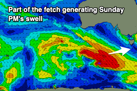
 Some new, inconsistent W/SW groundswell is due into the afternoon, generated by off axis, south-east tracking but strong fetches of severe-gale W/NW-NW winds moving through our swell window today.
Clifton should build to 2-3ft through the afternoon under that favourable wind regime, easing from 2ft+ Monday morning with N/NW tending variable winds.
From here we'll see the surf backing off in size and conditions will be favourable Tuesday with offshore tending E'ly winds, fresher N/NE on Wednesday but tiny.
From Thursday a couple of new S/SW groundswells are due, the first generated by a late forming polar fetch of strong to gale-force W/NW winds, with a secondary better pulse Friday generated by severe-gale to storm-force W'ly winds.
Thursday's looks to come in at 2ft, with Friday's more to 3ft, but a deepening low to our east will unfortunately bring increasing SE winds Thursday afternoon, stronger Friday. We'll look over this again on Monday though for any changes.
Beyond this the storm track looks to fire up towards Western Australia which isn't great for us, but more on this Monday. Have a great weekend!

