New swells but flukey winds Friday and Saturday
Southern Tasmania Surf Forecast by Craig Brokensha (issued Wednesday 16th June)
Best Days: Keen surfers Friday and Saturday, Sunday, Monday morning
Features of the Forecast (tl;dr)
- Tiny, easing W/SW groundswell tomorrow with light SE tending SW winds
- Inconsistent W/SW groundswell Fri with moderate SE tending S/SE winds, easing Sat with light W/SW-SW tending S winds
- New W/SW groundswell for Sun PM with N/NW tending variable winds, easing Mon with NW tending SW winds
Recap
Tiny 0.5-1ft waves yesterday, while our inconsistent W/SW groundswell for today has come in as forecast with sets to 1-1.5ft under light winds.
This week and weekend (Jun 17 – 20)
Today's swell will fade through tomorrow from a tiny 1ft and winds look to deteriorate as a broad and strengthening low to our north-east shifts south, bringing light SE tending SW winds.
This low will influence our winds into Friday and Saturday, spoiling a moderate sized, W/SW groundswell that's due Friday.
The polar low linked to this swell is weakening south of Western Australia with a fetch of storm-force W/SW winds projected towards us earlier this week, through our distant western swell window.
As a result the swell will be inconsistent, building to 2-3ft through the day across Clifton on Friday, easing back through Saturday from 2ft+.
A moderate SE tending S/SE breeze will create average conditions Friday, with light W/SW-SW winds Saturday morning, shifting S into the afternoon. While not ideal there'll still be OK waves for the keen.
Conditions should improve into Sunday with a N/NW tending variable breeze but we'll see a low point in swell early to 2ft.
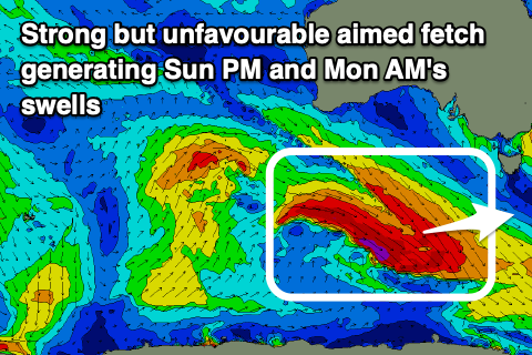
A new, inconsistent W/SW groundswell is due to arrive mid-morning though, generated by patchy severe-gale W/NW-W winds around a low forming south-west of Western Australia this afternoon and evening.
 As the low weakens and pushes east, it'll drag out gale to severe-gale W/NW winds behind it, generating some reinforcing W/SW groundswell for Monday.
Looking at the expected sizes and Clifton should build back to an inconsistent 2-3ft with those favourable winds, easing from a similar size Monday.
From here the surf will fade in size and power but with favourable NW winds ahead of a possible shallow change Monday, back offshore into Tuesday.
Longer term there's nothing too significant on the cards as mid-latitude lows continue to spawn over Western Australia and push east, but more on this in the coming updates.

