Nothing great but surf from Saturday
Southern Tasmania Surf Forecast by Craig Brokensha (issued Wednesday 2nd June)
Best Days: Beginners tomorrow, Saturday, Monday, Tuesday
Features of the Forecast (tl;dr)
- Tiny W/SW swell easing tomorrow with fresh N/NW tending variable winds
- Mix of swells for Fri with strong W/SW winds, biggest late, easing Sat with fresh N winds
- Building W/SW swell Mon, holding Tue with N tending N/NE winds, easing Wed with S winds
Recap
Tiny waves yesterday and this morning for beginners, but a little lift in energy was expected this afternoon to 1-1.5ft.
This week and weekend (Jun 3 – 6)
The tiny increase in inconsistent W/SW swell this afternoon should hold around 1-1.5ft tomorrow morning, ideal for beginners with a fresh N/NW tending variable breeze.
A new pulse of SW groundswell for Friday is on track, with sets to 1-2ft due, but this will be overridden by a building, close-range windswelly swell.
Strong to near gale-force W/SW winds will be projected right under us Friday, tending SW into the afternoon, kicking up a building W/SW tending SW swell to 2-3ft by late in the day.
Conditions will be poor though with winds shifting strong W/SW just after dawn, holding into the afternoon.
Saturday looks better as winds quickly revert back to the N'th as another front approaches from the west, and the mix of swells will ease back from the 2ft range.
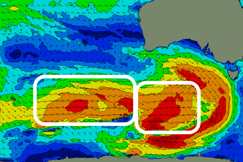
From Sunday we'll see a progression of stronger Southern Ocean frontal activity pushing east through our swell window, generating building levels of W/SW swell.
 The first swell producer should generate a fetch of W/SW gales Friday evening and Saturday, producing a good kick in size Monday to 2-3ft across Clifton, with a secondary pre-frontal fetch of gales keeping the swell around a similar size Tuesday and Wednesday.
Winds on Sunday and Monday look fresh from the N tending N/NE, clean Tuesday with N/NW tending variable winds ahead of S/SE change into the evening.
This change will be linked to a deepening and broad mid-latitude low across the south-east of the country, bringing onshore winds into the end of the week, but more on this next update.

