Swell on the build but mostly onshore
Southern Tasmania Surf Forecast by Craig Brokensha (issued Wednesday 26th May)
Best Days: Selected locations tomorrow, possibly early Friday, Saturday
Features of the Forecast (tl;dr)
- New W/SW swell for tomorrow with fresh W/NW tending strong W/SW winds, bigger Fri out of the S/SW with strong SW-S/SW winds, easing Sat with W/SW tending S/SW winds
- Easing S/SE swell Sun with W/NW tending variable winds
Recap
A small increase in inconsistent groundswell yesterday with clean 2ft waves on the coast, fading today and tiny.
This week and weekend (May 27 - 30)
Currently, a mid-latitude low is passing under the state, producing a slim and short-lived burst of strong to gale-force W/SW winds.
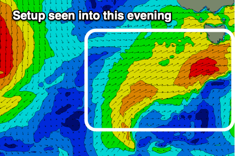
This is a bit patchier than forecast on Monday, but a secondary, weaker front will generate a better aligned fetch of strong to gale-force W/SW winds in our south-western swell window this evening and tomorrow morning.
 Size wise, mid-period energy from the W/SW-SW should come in at 2-3ft tomorrow, possibly building on dark as a third fetch of strengthening SW winds push up and into us.
This fetch of strong SW tending S/SW winds looks to generate 3-4ft surf into Friday morning, easing slowly into the evening, down to 2-3ft Saturday but stabilising.
Winds will be an issue with tomorrow morning seeing fresh W/NW breezes, tending strong W/SW into the afternoon, then strong SW tending S/SW on Friday.
Winds may linger from the W/SW into Saturday morning, creating average conditions, cleaner Sunday morning with a small, easing S/SE swell from the 2ft range.
As touched on last update, the longer term outlook remains void of any major surf, so the coming period is a bit hit and miss with all the swell arriving with poor winds.

