Good run of swell and conditions
Southern Tasmania Surf Forecast by Craig Brokensha (issued Monday 17th May)
Best Days: Tuesday, Wednesday, Friday, Saturday, Sunday
Features of the Forecast (tl;dr)
- Easing S/SW groundswell tomorrow with N/NW tending variable winds, smaller Wed with moderate to fresh N winds
- Building mix of swells late Thu with strong W/SW winds, peaking Fri AM with a N/NW tending N/NE breeze
- New W/SW swell for Sun with N-N/NE winds
Recap
Tiny clean waves Saturday and yesterday while today we've got a good increase in size to 2-3ft this morning, larger this afternoon as a strong new S/SW groundswell fills in but with bumpy, cross-shore winds.
This week and weekend (May 18 - 23)
Today's swell was generated by a strong polar low firing up over the weekend and we should see the bulk of size from this afternoon easing into tomorrow morning. It'll still be chunky in the morning, easing back from an easy 4ft across Clifton on the sets, smaller Wednesday and down from 2ft on the biggest ones.
Conditions should be great with a N/NW tending variable breeze tomorrow, moderate to fresh N all day Wednesday.
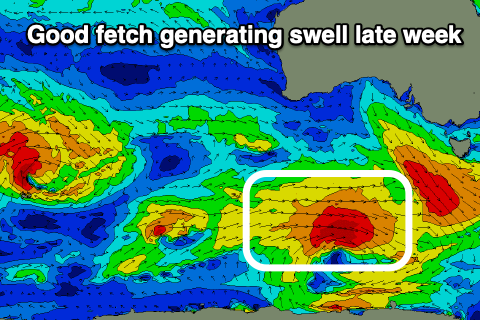
 Moving into the end of the week we're due to see a mix of W/SW swells, the first being a fun groundswell from a tight mid-latitude low dipping east-southeast through our swell window this evening before expanding tomorrow. We'll see a fetch of W/SW gales projected towards us, generating a fun 3ft of swell for late Thursday but more so Friday morning.
Also in the mix will be a close-range swell from a strengthening low right under us during Thursday. The low won't be overly strong and will track too quick, resulting in a short-lived swell under the size of what will be generated by the low mentioned in the paragraph previous.
The close-range low will bring a strong W/SW change Thursday though, with cleaner conditions due Friday as it pushes east, resulting in N/NW tending N/NE winds.
Saturday should be nice and clean again but the swell fading from the 2ft range on the sets.
From Sunday we'll be looking at less favourable westerly swells for the period with favourable winds out of the north as the storm track focusses itself north and west of our main swell window. More on this Wednesday though.

