Tiny weekend, more options next week
Southern Tasmanian Surf Forecast by Craig Brokensha (issued Friday 30th April)
Best Days: Tuesday morning keen surfers, Wednesday, Thursday, Friday
Features of the Forecast (tl;dr)
- Tiny weekend
- New W/SW groundswell building Mon but with a strong S change, easing Tue with lighter W/SW winds
- New W/SW swells for Wed Pm and Thu with N-NE winds
Recap
Tiny yesterday, while our new swell today is offering fun 1-2ft sets for the keen.
This weekend and next week (May 1 - 7)
We’ll see today’s swell fading in size overnight, tiny through the weekend.
Monday will start tiny but we’ll see our strong, long-period W/SW groundswell starting to fill in through the late morning and more so afternoon, likely peaking overnight and easing Tuesday.
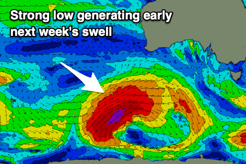
 The low linked to this swell has formed just east of the Heard Island region and has been generating a fetch of severe-gale to storm-force W/SW winds through our distant, western swell window. It's due to be strongest today south-west of WA, weakening slowly while projecting east tomorrow, breaking down Sunday.
The swell should build Monday and reach 3-4ft on the sets by dark, easing from the 3ft+ range on Tuesday. Winds are still looking poor Monday afternoon as a trough moves through bringing a strong S’ly change, but Tuesday looks a touch better with lighter W/SW winds. Wednesday should be cleaner but the swell small and back to 2ft.
We’ve got some fun new W/SW groundswell energy due Wednesday afternoon and Thursday from a strong frontal progression firing up under the country early next week. Fetches of pre-frontal W/NW gales will be followed by W/SW gales, producing surf to the 3ft range on the sets later Wednesday but more so Thursday and with great N’ly offshores, fresh NE into the afternoon.
Following this there’s more swell potential for next week but west in nature. More on this Monday. Have a great weekend!

