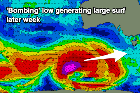
Another strong swell late week
Southern Tasmania Surf Forecast by Craig Brokensha (issued Monday 19th April)
Best Days: Wednesday morning for the keen, Thursday protected and Friday protected spots, Saturday morning, Sunday
Features of the Forecast (tl;dr)
- Easing SW swell tomorrow with strong S/SW winds
- Small, mid-period SW swell for Wed with N/NW morning winds
- Building W/SW swell Thu, strong late with a peak Fri under gusty W/NW winds
- Plenty of smaller, mid-period SW energy Sun-Wed
Recap
Still plenty of S/SW swell in the mix Saturday morning with clean 3-4ft waves and options aplenty, still solid but more from the SW direction yesterday. Today our second reinforcing SW groundswell is keeping Clifton chunky with good , clean conditions.
This week and weekend (Apr 20 - 25)
After the recent run of activity we'll see the surf slow down over the coming days ahead of a large, new W/SW groundswell later this week.
Tomorrow will be a lay day as a cold front pushes through bringing strong S/SW winds and poor conditions as today's swell eases in size.
Wednesday looks cleaner as winds shift back to the N/NW along with a new mid-period SW swell to 1-2ft.
A low point in size is expected Thursday morning but it'll only be temporary with building surf due into the afternoon ahead of a large W/SW groundswell Friday.
 This will be from the 'bombing' low that was discussed last week, with it doing so currently (dropping 24hPa within 24 hours) but the structure has changed a little.
What we'll see is is an initial burst of pre-frontal gale to severe-gale NW winds this evening and tomorrow, generating a small pulse of W/SW groundswell for Thursday midday, followed by much better severe-gale to storm-force W/SW fetch projecting east-northeast towards us. This will then be overtaken by a final bursy of gale to severe-gale W/SW winds, generating a large W/SW groundswell.
Size wise Thursday should build through the day to 2ft by midday with more size later to 4ft ahead of the swell proper peaking Friday morning to 5-6ft across Clifton. The swell will have plenty of west in the direction and winds on Thursday should be favourable most of the day, gusty from the W/NW tending W and then gusty W/NW on Friday.
The size will ease into Friday afternoon and further Saturday from 3-4ft, while persistent, background and weaker polar fronts will continue to generate fun pulses of mid-period SW swell Sunday through mid-next week. More on this in the coming updates.

