Strong swells and favourable winds
Southern Tasmania Surf Forecast by Craig Brokensha (issued Wednesday 14th April)
Best Days: Selected locations tomorrow, possibly early Friday, Saturday
Features of the Forecast (tl;dr)
- Building W/SW swell Thu with NW tending stronger W/SW winds, solid out of the SW-S/SW Fri with W/NW winds, tending NW on dark
- Smaller Sat AM with a new swell for the PM, Sun and Mon with favourable morning N/NW winds
Recap
Clean, easing surf yesterday, tiny today with increasing winds as a strong mid-latitude low edges in from the west.
This week and next (Apr 15 - 23)
Currently we've got a strong mid-latitude low pushing in from the west, a little too far north of our swell window, but as the low moves across us this afternoon and evening, it'll drag up a strong polar front behind it.
A fetch of W/SW gales will be generated briefly through our swell window today, kicking up 2ft+ of W/SW swell for tomorrow morning, but a broader and better aligned fetch of SW gales pushing up towards us should generate a larger SW groundswell for late in the day to 3-5ft by dark.
S/SW gales on the backside of the polar low will produce a good reinforcing S/SW groundswell for Friday, with sets to 4-5ft in the morning, easing slowly through the day and then down from 2-3ft Saturday morning.
Winds will be NW at dawn tomorrow but strengthen and quickly shift W and then W/SW into the afternoon with the building swell. Friday looks to see W/NW winds most of the day, tending NW on dark. Saturday will then see fresh N/NW winds, shifting SW late afternoon.
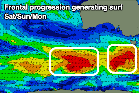
 Moving into the afternoon and more so Sunday/Monday, we'll see some new pulses of W/SW-SW groundswell from back to back cold fronts firing up on the back of the mid-latitude low/polar front combo.
Fetches of W-W/SW gales should produce moderate sized surf, with the first filling in Saturday afternoon, keeping 2-3ft waves hitting Clifton but peaking Sunday to 3ft, with a secondary front keeping the size up all day, easing Monday from 2-3ft.
Winds will remain favourable and N/NW in the mornings, shifting W/NW Sunday afternoon but holding all day Monday.
Longer term there's plenty more activity on the cards with a strong polar low possibly generating a strong swell late week. More on this Friday.

