Active period of surf ahead
Southern Tasmania Surf Forecast by Craig Brokensha (issued Monday 12th April)
Best Days: Tomorrow morning, Thursday, Friday protected spots, Saturday, Sunday
Features of the Forecast (tl;dr)
- Easing S/SW swell tomorrow with N/NW tending N/NE winds
- Building W/SW swell Thu with NW tending W/SW winds, stronger out of the S/SW on Fri with strong W/SW winds, easing Sat with gusty N/NW winds
Recap
A clean though tiny start to the weekend, but some new, weak W/SW swell started to show late in the day Saturday, ahead of our large W/SW-SW groundswell yesterday. The morning was reported at 4ft but the swell kicked further through the day though the direction kept protected spots on the small side.
Today there was still a bit of swell about but conditions were average and the size not enough for protected spots.
This week and weekend (Apr 13 - 18)
We'll see the current swell continue to back off in size tomorrow but clean up with fun, 1-2ft sets out there for the keen.
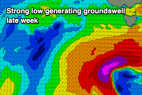
During last week's outlook, the remnants of Tropical Cyclone Seroja weren't expected to provide anything of note for us, but now we're looking at a much better and more significant swell generating system.
 Seroja is drifting south-east across Western Australia and once in the Bight, will merge with a mid-latitude low that's currently south of that state.
This low will generate severe-gale W'ly winds too far north of our swell window, but as it pushes east, it'll drag up a strengthening polar front behind it which will be right in our swell window.
An initial fetch of W/SW gales will be projected under us Wednesday afternoon and evening, kicking up some W/SW swell Thursday to 2ft+. A much better fetch of severe-gale SW winds will be projected through our southern swell window Wednesday evening and Thursday, producing a larger S/SW groundswell for Friday coming in at 4-5ft across Clifton through the morning, easing slowly into the afternoon, with easing surf from 2-3ft.
Winds on Thursday will shift from NW to W/SW while strengthening while strong W-W/SW winds are due all Friday. Conditions will become clean into Saturday with a gusty N/NW breeze, but we'll confirm this Wednesday.
Following Friday's swell there's plenty more frontal activity on the cards, generating SW groundswell pulses for next week. More on this next update.


Comments
God damn I'm heading down for a MTB trip but I think I'm going to have to abandon my plans for a day or 2 late next week!
Where are you riding, Mitch?
Fucking SHIPPIES!!!!
Nothing gets my blood pumping like a good chart, even when I haven't surfed since Nov 2019.
Got a DH booked for 6 days over 2 weekends at Maydena
Your last line gets my blood pumping.
Enjoy...
Cheers Stu. let me know if you come up north we can go riding, 1/2 price flights atm. Bring the family!