Upgrade in the weekend's swell
Southern Tasmania Surf Forecast by Craig Brokensha (issued Wednesday 7th April)
Best Days: Tomorrow, Saturday, Sunday and Monday selected spots, Tuesday
Features of the Forecast (tl;dr)
- Easing surf tomorrow with a N/NW breeze, strong SW change mid-morning Fri
- New SW swell Sat with strengthening N/NW tending W/NW winds
- Large W/SW-SW groundswell filling in Sun (kicking late Sat) with strong W/SW tending SW winds, easing Mon from the S/SW with strong SW tending S/SW winds
Recap
Clean, easing surf yesterday from 2-3ft, still 2ft today and nice and clean.
This week and next (Apr 8 - 16)
We'll still see fun 1-2ft waves across Clifton tomorrow morning as all the frontal activity to our west and under us since the weekend continues to provide decent surf.
A light N/NW breeze is expected to hold all day, so there'll be plenty of time to get wet.
Friday looks average as a weakening polar front moves in, bringing strong SW winds (W'ly at dawn) but not much in the way of swell above 1-2ft.
The earlier stages of this front today, under Western Australia should generate a bit more size Saturday to 2ft and a strengthening N/NW tending W/NW breeze will favour protected spots.
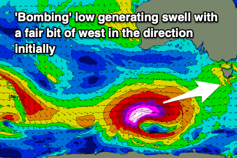
 Of greater importance is the swell from the 'bombing' low, with it still on track to drop over 24hPa of central pressure within a 24 hour period from this afternoon through tomorrow.
This will occur on the polar shelf, south-west of Western Australia, with a great fetch of storm-hurricane force W/SW winds expected to be projected east-northeast and then north-east up towards us while slowly weakening.
The slow movement and projection will result in a captured fetch scenario and greater than normal wave growth, resulting in an oversized, long-period W/SW tending SW groundswell event for Sunday.
The size is looking bigger than forecast on Monday with the swell likely to build late Saturday to 2-3ft, peaking Sunday to strong 6ft, but with that W/SW-SW direction.
 On the backside of the swell we'll see it shifting more S/SW in direction, easing from 3-5ft Monday morning, back to 1-2ft Tuesday.
Winds will be strong from the W/SW tending SW on Sunday, SW-S/SW on Monday but then back offshore Tuesday.
Longer term there's nothing too significant on the cards, though the remnants of Tropical Cyclone Seroja off the WA North West may move across us mid-week bringing a burst of swell, but more on this Friday.

