Good run of surf from Sunday
Southern Tasmania Surf Forecast by Craig Brokensha (issued Wednesday 31st March)
Best Days: Sunday, Monday morning, Tuesday morning, Wednesday morning, Thursday
Features of the Forecast (tl;dr)
- Tiny mid-period SW swell for Sat
- Better W/SW swell building Sun, peaking Mon, easing a touch into Tue and then down into Wed PM
- Favourable winds each morning from Sun to Wed ahead of sea breezes
Recap
Monday's windswell eased back from a clean, fun 1-2ft yesterday with tiny surf today.
This week and weekend (Apr 1 - 9)
The surf will remain tiny over the coming days with favourable morning conditions.
We'll likely see a small pulse of mid-period swell for Saturday to 1ft or so, but we've got our better run of swell from Sunday to discuss.
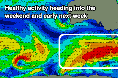
Over the coming days we'll see pre-frontal W-W/NW winds setting up an active sea state for a stronger progression to move over, generating strong to near gale-force W/SW winds through our western swell window Saturday and south-western swell window Sunday.
 A final strong polar front is then due to generate additional W'ly gales in our swell window Monday, helping to prolong the swell event from Sunday through Wednesday.
Size wise, the first, less favourable pulse of W/SW swell should fill in Sunday, with the better angled swell for Monday, easing a touch Tuesday but steadying through Wednesday morning.
Size wise, we're looking at building surf to 2-3ft during Sunday, coming in at 3ft on Monday, easing a touch to 2-3ft Tuesday morning though holding this size into Wednesday morning, easing into the afternoon.
Winds look favourable with a NW tending W'ly wind on Sunday, NW Monday morning ahead of S/SE sea breezes and similar Tuesday but with a morning N/NW breeze. Wednesday will see light N'ly winds ahead of sea breezes, with smaller waves to end off the week.
Longer term a strong polar front firing up late next week should generate some new W/sW swell next weekend, but more on this Friday.

