Strong swell for the weekend
Southern Tasmania Surf Forecast by Craig Brokensha (issued Wednesday 24th February)
Best Days: Selected locations tomorrow, possibly early Friday, Saturday
Features of the Forecast (tl;dr)
- Tiny, mid-period S/SW swell Fri with W/SW tending S/SW winds
- New, strong SW groundswell for late Sat, peaking Sun AM with N/NE tending S/SE winds
Recap
Clean, fun 1-2ft waves across Clifton yesterday morning and this morning, but make the most of it as there's no decent surf on the cards until the weekend.
This week and weekend (Feb 25 - 28)
Discard the end of the week. Tomorrow will be tiny with fresh N'ly winds ahead of a mid-late afternoon W/SW change as a weakening cold front pushes across us.
A very weak fetch of S/SW winds trailing the front will kick up a tiny S/SW swell Friday but conditions will be poor with a fresh to strong W/SW tending S/SW breeze.
 Lingering onshore, though tending variable winds are likely Saturday but with no size.
We then look at the SW groundswell due on Sunday.
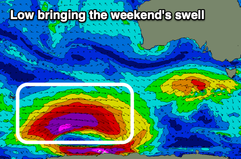
The source of this swell is another 'bombing' low which developed around the Heard Island region yesterday as Tropical Cyclone Guambe was absorbed into the westerly storm track.
A fetch of unfavourably aligned storm-force W'ly winds were generated through yesterday afternoon with a better fetch of severe-gale to storm-force W-W/NW winds due to be generated south-west of WA today. The low will weaken while continuing on a slight east-southeast track tomorrow through our swell window, breaking down south-west of us on Friday.
We should see a late increase in size Saturday though with sea breezes, best Sunday morning as the swell peaks to 3ft to possibly 4ft along with variable N winds ahead of sea breezes. Monday will also be clean as the swell eases from 2ft+.
Longer term a couple of strengthening polar fronts under us next week look to generate some new swell, but more on this Friday.

