Nothing great but a few options
Southern Tasmania Surf Forecast by Craig Brokensha (issued Monday 22nd February)
Best Days: Tomorrow morning, Wednesday, Sunday morning
Features of the Forecast (tl;dr)
- Mix of W/SW swells tomorrow with W-W/NW winds in the AM, shifting W/SW late morning and then S/SW, easing Wed with N/NW tending E/NE winds
- Tiny, mid-period SW swell Fri with S winds
- New, strong SW groundswell for Sun with variable tending S/SE winds
Recap
Tiny, onshore surf over the weekend, while this morning conditions are cleaner with 1ft sets. A strong new W/SW groundswell has hit Cape Sorell and it should be showing across Clifton now along with a strengthening W/NW breeze, shifting W/SW as the swell becomes stronger.
This week and weekend (Feb 23 - 28)
This afternoon's increase in W/SW groundswell and some additional mid-period energy were generated by the same strong storm. That being a 'bombing' low firing up in our far swell window, weakening while projecting east-northeast towards the Bight, but then maintaining strong to near gale-force W'ly winds just within our western swell window.
The remnants of this low is now weakening further while pushing across us, bringing today's change, with the size due to reach 2ft across Clifton this evening, holding a similar size most of tomorrow, then easing from 1-2ft. During the peak of the swell there might be the odd bigger one if we're lucky.
Winds look OK for protected spots tomorrow and W/NW early, shifting W/SW late morning and then S/SW into the afternoon. Wednesday is the pick for the cleanest conditions with a light N/NW offshore, E/NE into the afternoon.
 The rest of the week looks poor with no significant swell besides a tiny, mid-period increase in SW energy Friday. Winds will swing onshore though with a trough and weak low forming off our East Coast with better surf due Sunday.
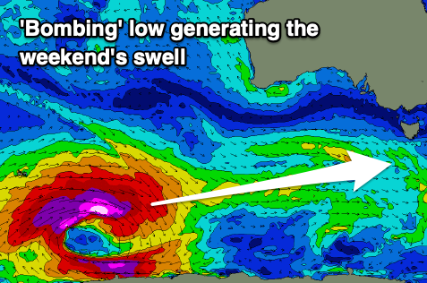
As touched on last week, a stronger and better groundswell is due on the weekend, generated by another 'bombing' low around the Heard Island region. The catalyst for the 'bomb' will be Tropical Cyclone Guambe, currently south-east of the South African coast, being absorbed into the westerly storm track.
This will see a rapid intensification of a polar low, with a great though distant fetch of storm-force W'ly winds due to be projected through our swell window as the low tracks east-northeast.
It'll break down south-southwest of Western Australia, with the swell due to arrive later Saturday but peak Sunday to a strong though inconsistent 3ft across Clifton. Winds will hopefully go variable in the morning ahead of sea breeze, but we'll confirm this through the week.

