Small swell for next week
Southern Tasmania Surf Forecast by Craig Brokensha (issued Friday 19th February)
Best Days: Wednesday morning
Features of the Forecast (tl;dr)
- Small W/SW groundswell pulse Sun AM but with less than ideal winds
- Better mix of W/SW swells building Mon PM but with strong W/SW winds, holding Tue with gusty W-W/SW tending SW winds, easing Wed with light NW winds
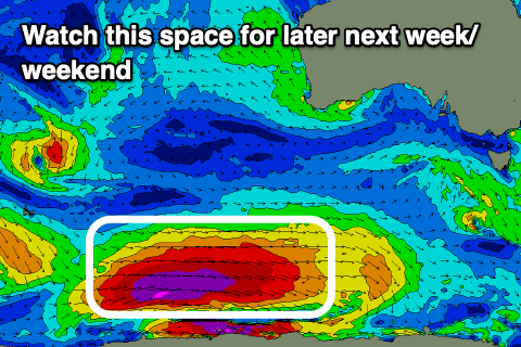
- Strong SW groundswell late next week/weekend
Recap
Small to tiny surf the last couple of days, ideal for beginners.
This weekend and next (Feb 20 - 26)
The weekend looks smaller than the surf we've been seeing yesterday and today, and a trough will bring a shallow onshore change tomorrow morning at or shortly after dawn, strengthening through the day.
The onshore winds look to linger Sunday with a tiny pulse of W/SW swell from a south-east tracking low through our swell window today. It looks 1-2ft max and onshore.
Of greater importance are the mix of W/SW swells due into early next week, though winds look to be an issue again.
The groundswell component was generated yesterday and is still being produced today by a 'bombing' low around the Heard Island region. A fetch of storm-force W'ly winds are now slowly weakening and moving through the periphery of our western swell window.
The low is due to keep weakening while moving slowly east on the weekend, generating a fetch just on the edge of our western swell window.
This will limit the size and consistency of the swell but we should see a mix of swells building Monday, likely reaching 2ft into the evening, coming in around a similar size Tuesday. There might be the odd bigger one at times if we're lucky but winds are due to swing W/SW and strengthen Monday afternoon with a change, remaining strong W-W/SW Tuesday morning, shifting SW through the day.
 Wednesday looks the pick with light offshore winds and easing 2ft sets.
Now, longer term we've got a significant polar low due to form in our swell window through the middle of next week. This is forecast to project a fetch of severe-gale to storm-force W'ly winds through our south-western swell window, projecting towards us while weakening late week.
A moderate sized + SW groundswell is due though winds are a touch suss. More on this Monday Have a great weekend!

