Make the most of the current surf
Southern Tasmania Surf Forecast by Craig Brokensha (issued Monday 15th February)
Best Days: Tomorrow morning
Features of the Forecast (tl;dr)
- Easing mid-period SW swell tomorrow with strong N/NE tending NE winds
- Inconsistent W/SW groundswell building Mon with W/NW tending E/SE and then W/SW winds, mixed with a mid-period swell Tue but with W/SW tending S winds
Recap
Small, clean fun waves the last couple of days to 1-2ft and with morning offshore winds, stronger and from the east into the afternoons.
This week and next (Feb 18 - 26)
Make the most of the current small surf, as it'll back off from 1-2ft tomorrow morning, tiny to flat until at least early next week.
Winds tomorrow will be favourable again though stronger, out of the N/NE in the morning and more NE into the afternoon, similar Friday but likely N/NE all day.
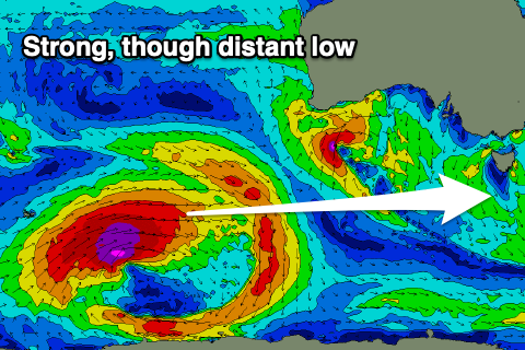
Our new W/SW groundswell and mid-period swell for early next week is still on track, with the 'bombing' low forming last night in the Heard Island region. We're now seeing a fetch of storm-force W/SW winds projected east towards us, before moving east-northeast and on the edge of our swell window.
This will provide an inconsistent W'ly groundswell for Monday afternoon and Tuesday morning to an infrequent 2ft across Clifton.
 The remnants of the low should project strong W'ly winds just within our western swell window through the weekend before passing under is in an even weaker form Monday.
This will add some additional mid-period W tending W/SW swell to the mix, coming in at a similar sized 2ft.
Winds on Monday look to vary, with a W/NW offshore, giving into E/SE sea breezes ahead of a late afternoon W/SW change as a trough pushes in. This looks to bring W/SW tending S winds on Tuesday, creating poor conditions. Wednesday may see variable breezes but the swell will be on the way out.
Longer term we may be looking at a good SW groundswell for next weekend, but more on this Friday.

