Small run of waves
Southern Tasmania Surf Forecast by Craig Brokensha (issued Monday 15th February)
Best Days: Selected locations tomorrow, Wednesday, Thursday morning
Features of the Forecast (tl;dr)
- Small levels of mid-period swell for Tue/Wed/Thu, most consistent and best Wed with strengthening winds from the N/NE tending E/NE
- Mix of W/SW swells for Mon/Tue next week
Recap
Tiny surf over the weekend, building late yesterday but coming in onshore and slow today.
This week and weekend (Feb 16 - 21)
We've got small pulses of swell for the coming days, nothing too big and mostly 1-2ft or so, though best Wednesday and more to that 2ft range. This is from persistent but not overly strong frontal activity along the polar shelf since late last week.
Winds will improve though favour some spots over others, with a N/NE tending fresh E/NE breeze tomorrow, stronger N/NE tending E/NE on Wednesday.
 The surf should start easing Thursday from 1-2ft along with similar strong N/NE tending E/NE winds.
Following this there's nothing significant on the cards at all, so maybe try the East Coast notes for more options.
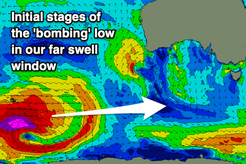
Into next week we're due to see an inconsistent though good W/SW groundswell filling in, generated by a 'bombing' low forming around the Heard Island region Wednesday. This low will generate a fetch of storm to hurricane-force W'ly winds, weakening slightly while projecting east-northeast through the end of the week.
 Once under the country on the weekend it'll continue to generate strong W/SW winds, pushing in closer to us Monday. We should see a very inconsistent W/SW groundswell mixed in with smaller, more consistent mid-period energy, building Monday and peaking Tuesday to 2ft or so, if not for the odd bigger one. Conditions look favourable at this stage in the mornings, but more on this Wednesday.

