Windy, building swells this period
Southern Tasmania Surf Forecast by Craig Brokensha (issued Friday 15th January)
Best Days: Protected spots Sunday through Tuesday, Wednesday, Friday through Sunday next weekend
Features of the Forecast (tl;dr)
- Building SW swell energy Sun but with strong W/SW winds, shifting W/NW on dark
- Mix of swells Mon with a morning NW winds
- Larger S/SW groundswell Tue AM with strong SW winds
- Cleaner, easing S/SW swell Wed AM
Recap
Tiny surf yesterday and today, but there's plenty more action to come.
This weekend and next week (Jan 16 - 22)
Tomorrow will be the last day of tiny surf ahead of windy, building swells through Sunday and early next week as a strengthening node of the Long Wave Trough pushes east across us.
We'll see a series of polar fronts projected up and across us, with the first moving in tomorrow afternoon, bringing an increase in mid-period swell for the morning Sunday, a bit stronger into the afternoon as the periods draw out.
Size wise we should see 3ft surf in the morning, pushing to 3ft+ into the afternoon but with strong W/SW winds. The next approaching front may swing winds W/NW late, so keep an eye out for that window.
This secondary front should maintain 3ft surf through Monday, if not for the odd bigger one and under NW tending stronger W/SW winds late morning.
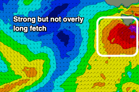
 Into Monday evening, the strongest of the polar fronts is expected to project up and across us while deepening, with a fetch of severe-gale W/SW tending S/SW winds due to be generated.
The fetch will move fairly quickly east and have no length to the severe-gale component, resulting in a short-lived spike in S/SW swell Tuesday morning to 4-5ft or so, easing steadily through the day and back to 3-4ft through the afternoon. Wednesday looks smaller again and back to 2ft to possibly 3ft.
Winds will be strong SW on Tuesday, swinging back to the W/NW on Wednesday as the swell fades, giving into SE sea breezes.
Moving into the end of the week, a series of strong polar fronts swinging in from east of the Heard Island region should produce fun pulses of W/SW groundswell Friday through the weekend and with favourable winds. More on this in Monday's update though. Have a great weekend!

