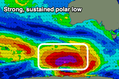
Strong swell this week with varying winds
Southern Tasmania Surf Forecast by Craig Brokensha (issued Monday 4th January)
Best Days: Tomorrow morning, Thursday, Friday morning, Saturday morning for the keen, Sunday and Monday mornings
Features of the Forecast (tl;dr)
- Strong W/SW tending SW groundswell building Wed PM, peaking Thu AM with light S-SW winds
- Small mid-period W/SW swell persisting Sun/Mon
Recap
Small to tiny surf all weekend and into this morning for bigger boards and beginners.
This weekend and next week (Jan 5 - 10)
Updated for those interested..
//
Small surf should persist tomorrow around 1-2ft or so ahead of a little kick in mid-period energy later in the day, holding Wednesday morning. This looks to provide more consistent 2ft sets but winds will be an issue. Tomorrow morning light S/SE winds will create a few little bumps/lumps, freshening through the day with Wednesday seeing strengthening S/SW winds, creating poor, choppy surf.
We then look to the strong, long-period W/SW tending SW groundswell that's due to arrive Wednesday afternoon, peaking Thursday morning. The low formed around the Heard Island region on the weekend and has since been generating a great fetch of severe-gale to storm-force W/NW-W winds through our western swell window.
The low is weakening slowly today while projecting east, more through our south-western swell window, breaking down tomorrow, though a secondary weaker front moving in on top of it will help prolong the swell event through Thursday.
The swell should arrive Wednesday afternoon and build to a strong 3-4ft by dark, with Thursday seeing solid 4-5ft sets across Clifton in the morning, easing into the afternoon but then smaller Friday and dropping from 3ft Friday morning, continuing at 1-2ft Saturday.
Local winds on Thursday look a touch dicey though workable and light S/SW-SW ahead of S/SE sea breezes, variable N Friday morning ahead of sea breezes. Saturday may see lingering S/SW winds again, but we'll review this Wednesday.
Longer term, trailing weaker frontal activity should generate some new swell for Sunday/Monday but more on this in the next update.
//
I had the whole notes written and ready to go, and then a storm pushed through Sydney, taking out the power in the office.
 So re-capping quickly, tomorrow should remain around 1-2ft with light winds in the morning, strengthening onshore Wednesday.
A strong polar low will generate a strong, long-period W/SW tending SW groundswell, building later Wednesday to 3-4ft, peaking Thursday morning to 4-5ft with light S-SW winds.
Friday should still be 3ft and easing with a light, variable N'ly wind ahead of S/SE sea breezes, 1-2ft Saturday though possibly light onshore.
Some fun small W/SW swell should keep Clifton around 2ft Sunday/Monday with morning variable winds.
Longer term there's nothing too significant so make the most of the coming swell.


Comments
Iv'e added in what I recovered from yesterday's power outage.