Stronger swell due on the weekend
Southern Tasmania Surf Forecast by Craig Brokensha (issued Friday 11th December)
Best Days: Tomorow morning, Sunday and Monday selected spots
Recap
Poor conditions yesterday with onshore winds and a building swell, a bit cleaner today but nothing special with more size to 2ft+.
This weekend and next week (Dec 12 - 18)
Yesterday afternoon and today, our first pulses of S/SW swell have filled in, and we've got a similar sized reinforcing swell due this afternoon from a broad fetch of W'ly winds moving in through our swell window yesterday.
A drop in size from 2ft+ is due tomorrow morning, back to 2ft temporarily Sunday morning ahead of our new SW groundswell.
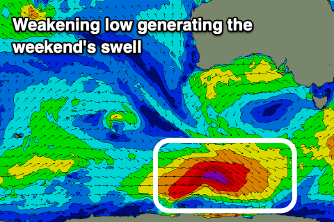
 This groundswell was generated yesterday afternoon through this morning from a strong low that formed while tracking south-east from the Indian Ocean, aiming a fetch of severe-gale NW winds through our swell window.
The low is now breaking downs south-west of us, with the groundswell due to fill in Sunday and provide good 3ft+ sets into the afternoon when it peaks. Due to the low weakening today, the swell will ease quickly Monday, dropping from 2ft Monday morning.
Looking at the local winds and tomorrow morning a variable tending light N/NE breeze is due, strengthening from the E/NE through the afternoon. Sunday will then see fresh N/NE tending strong E/NE winds, similar Monday.
Looking into the rest of next week, and a small low forming west of us while dropping south-east should produce a small spike of mid-period W/SW swell for Wednesday/Thursday but the lack of strength will limit the expected size.
Nothing over 1-2ft is expected and unfortunately winds look onshore, out of the E/SE in any case, but more on this Monday. Have a great weekend!

