Lots of swell to come
Southern Tasmania Surf Forecast by Craig Brokensha (issued Wednesday 9th December)
Best Days: Friday morning, Saturday morning, Sunday, Monday morning
Recap
A good, building S/SW swell through yesterday coming in at 3ft on the sets through the morning though pushing above this into the afternoon. Today the swell has eased with more favourable winds.
This week and weekend (Dec 10 - 13)
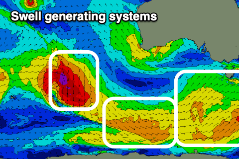
From tomorrow we've got a very active forecast period ahead with a series of cold fronts skirting around a strong high that's currently moving in under the country.
The first two are broad but not overly strong with good fetches of 25-30kt+ winds moving through our southern swell window.
 We'll see an initial increase in mid-period S/SW swell building tomorrow and reaching 2-3ft across Clifton into the afternoon, holding Friday morning. A secondary polar front should maintain this size later Friday and Saturday morning, before easing through the day.
Winds tomorrow will be poor as the first front moves through, bringing strong SW tending S/SW winds.
Friday looks much better with a lighter W/NW offshore, shifting SW and then S'ly into the afternoon. Saturday looks great with variable N'ly offshores ahead of S/SE sea breezes.
A low point is expected early Sunday, back to 2ft or so, but a strong low pushing south-east from the Indian Ocean through our swell window over the coming days will generate a new SW groundswell for the afternoon.
A fetch of severe-gale NW winds in our medium-range swell window should kick the size back to 3ft+ through Sunday afternoon with strengthening N/NE tending NE winds. This will favour some spots over others with the N/NE winds due to continue Monday as the swell eases from 2ft or so.
Longer term the outlook goes quiet, so make the most of the coming swells.

