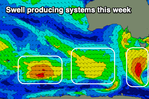
Lots of swell this period
Southern Tasmania Surf Forecast by Craig Brokensha (issued Monday 7th December)
Best Days: Protected spots tomorrow, Wednesday, Friday morning, Saturday morning, Sunday morning
Recap
Saturday was great for beginners with tiny, 1-1.5ft waves, near flat yesterday and windy.
Today we've got a building W/SW windswell from a strong mid-latitude low pushing across and under us. More size and energy is due over the coming days.
This week and weekend (Dec 8 - 13)
This afternoon's increase in size is from the least favourably aligned part of the mid-latitude that's moved across us, and we'll see a better S/SW swell fill in tomorrow. This was generated by a great fetch of strong to gale-force S/SW winds directed through our southern swell window from last night through today.
The swell should peak through the middle of the day and provide 3-4ft surf across Clifton and with favourable winds for protected spots, W-W/NW all day and fresh.
 Wednesday looks clean as well with N/NW tending W/NW winds as the S/SW swell eases from 2ft to possibly 3ft. There'll also be some weak mid-period W/SW swell in the mix from a weak front pushing in tomorrow.
This weak front will be ahead of a broader and more elongated polar front pushing in later week, aiming a fetch of strong SW winds through our swell window.
The swell should build Thursday and reach 2-3ft across Clifton, easing from a similar size Friday.
Following this there'll still be plenty of polar frontal activity dripping south-east from the Indian Ocean, pushing east along the polar shelf and through our swell window late in the week.
This should keep Clifton active into the weekend with surf to 2ft+, fading Monday from 1-2ft.
Local winds look average Thursday and out of the W/SW, swinging S/SW through the day as the swell producing front moves through.
From here conditions are favourable with morning offshores, W/NW Friday morning, NW Saturday morning and N'ly Sunday ahead of afternoon onshores.

