Slow weekend, lots of activity next week
Southern Tasmania Surf Forecast by Craig Brokensha (issued Friday 27th November)
Best Days: Tomorrow morning, Monday morning, Tuesday, Wednesday, Thursday
Recap
The surf started tiny yesterday morning with a slight delay on the arrival of our strong W/SW groundswell but it kicked strongly into the late afternoon with 3-4ft sets across Clifton along with an onshore breeze.
Today the surf is easing from 3ft with clean conditions at selected breaks.
This weekend and next week (Nov 28 – Dec 4)
The current swell will continue to ease this afternoon, dropping from 1-2ft tomorrow morning across Clifton with a light NW offshore ahead of SE sea breezes.
Sunday looks tiny and with a strong S/SW change moving through before dawn as a trough slides in from the west.
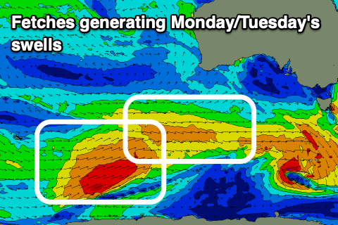
 Moving into next week we've got a mix of W/SW swells on the way, originating from a strong polar low that's formed east of Heard Island.
At the lows core, a slow moving fetch of gale to severe-gale W/SW winds are being generated with a front spawning east ahead of the low, projecting weaker W'ly winds towards us.
This should produce a small, fun mid-period W/SW swell for Monday to 1-2ft or so, with the groundswell due Tuesday, providing infrequent 2ft+ sets.
Winds on Monday look offshore in the morning, fresher out of the E/NE into the afternoon.
Tuesday should be clean all day with a freshening N/NE tending N/NW breeze ahead of a strengthening cold front.
 This strengthening cold front has been upgraded since Wednesday and we're expected to see it form into a significant low south of us during Tuesday evening and Wednesday. A fetch of developing severe-gale W/SW winds are forecast to be generated in our swell window (right), producing a moderate to possibly large sized SW tending S/SW groundswell for Wednesday/Thursday. With the low sitting south of us winds look favourable and out of the west, but we'll review this Monday.
Have a great weekend!

