Lots of swell on the way with clean conditions
Southern Tasmanian Forecast by Craig Brokensha (issued Wednesday 26th August)
Best Days: Beginners tomorrow, Friday, Saturday, Sunday, Monday
Recap
Fun and clean waves to 2ft yesterday, back to 1-2ft this morning.
This week and weekend (Aug 27 - 30)
Tomorrow looks tiny as we fall in between swells, though ideal for beginners with a persistent N/NW offshore ahead of an after dark change.
This change will be linked to a vigorous and severe frontal system moving in from the west, with it upgraded in strength from Monday.
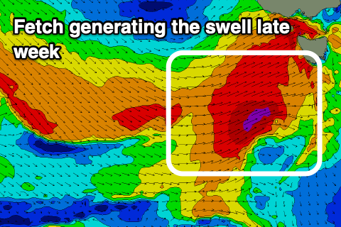
 The front is currently strengthening south-southwest of WA and will produce a fetch of severe-gale W/SW winds through our western swell window this evening and tomorrow. While the fetch strength is great, the speed at which it moves is a little too fast, but we should still see a strong pulse of new W/SW tending SW swell through Friday.
The morning looks to be 3-4ft out of the W/SW, with the peak in energy into the afternoon from the SW to 4ft+.
With the fast movement of the front we’ll see winds swing back to the W/NW and hold all day Friday, with N tending variable winds on Saturday as the swell drops rapidly back from 2-3ft.
Moving into Sunday and the models diverge regarding a mid-latitude storm moving in from the west. GFS has it stronger and a swell producer for us Sunday/Monday, but EC has it higher resulting in no decent new swell.
With this we’ll have to have another look at the forecast on Friday.

