Tiny, clean weekend, better swell next week
Southern Tasmania Surf Forecast by Craig Brokensha (issued Friday 24th July)
Best Days: Beginners tomorrow, Tuesday, Wednesday
Recap
A reinforcing swell yesterday to 1-2ft across Clifton, holding through today with cleaner conditions reported.
This week and weekend (Jul 25 – 31)
Our current run of small swell is expected to fade through the weekend, though tomorrow should remain surfable for the keen on bigger boards with a tiny pulse of W/SW groundswell from a low that formed south-southwest of WA on Wednesday. This low tracked south but generated a good fetch of W'ly gales with 1-1.5ft sets likely, fading into the afternoon and tiny Sunday.
A N/NW tending NE breeze is due tomorrow and then N tending N/NE breeze Sunday.
 As touched on last update, we've got a more active period for next week with east-southeast tracking frontal systems moving in from the Indian Ocean due to strengthen through our swell window.
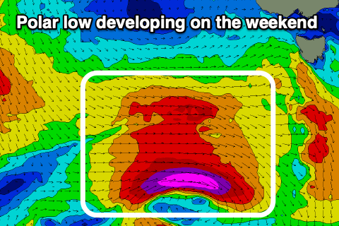
The first and best looking system is due early next week, with a great fetch of strengthening gale to severe-gale W/SW winds developing in our western and then south-western swell windows Sunday and Monday.
The polar low will move under us Monday evening, with the W/SW tending SW groundswell due to build Tuesday and reach a strong 3-4ft through the day, easing quickly from 2ft Wednesday morning.
With the low moving through Monday evening winds will remain favourable and variable through the morning ahead of possible sea breezes, N/NW tending W/SW Wednesday. There's an outside chance a low in the Tasman will edge south and spoil this, but we'll confirm on Monday.
Behind this initial low follow up fronts will edge in from the west but be more zonal, leading to smaller pulses of W/SW groundswell. We'll have a closer look at this Monday though. Have a great weekend!

