Lots of surf days to come
Southern Tasmania Surf Forecast by Craig Brokensha (issued Friday 2nd August)
Best Days: Sunday morning, Monday, Tuesday
Recap
Clean 2ft waves yesterday morning ahead of a late and large spike in new swell from a very intense mid-latitude low passing under us. This swell has held in at 3-4ft this morning but will ease rapidly through the day.
Today’s Forecaster Notes are brought to you by Rip Curl
This weekend and next week (Aug 3 – 9)
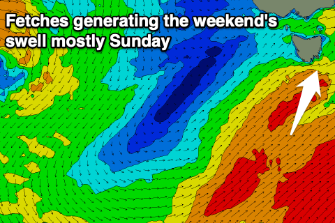
We've got plenty more swell to come over the period, with the first for tomorrow morning being a new W/SW groundswell from a gale-force pre-frontal W/NW fetch that's currently swinging in from the west.
A good kick in size to 2-3ft is expected across Clifton in the morning, building further later in the day as a trailing fetch of SW gales are projected up and towards us.
 Winds will unfortunately be onshore with the front moving through, with a fresh SW tending W/SW breeze, much cleaner Sunday as winds tend W/NW, though it'll likely still be lumpy and not perfect with onshore winds right up until dawn.
Easing sets from 3ft to near 4ft are due, smaller and cleaner Monday with easing 2-3ft sets under a N/NW offshore.
A reinforcing S/SE groundswell is due on Tuesday, produced by a tight but strong polar fetch of storm-force SE winds at the base of the frontal progression moving through tomorrow.
Sets to 2-3ft are due in the morning, easing through the day under a N/NW tending W/NW breeze.
Into the second half of the week there's nothing too significant on the cards besides small and flukey pulses of swell. A small and persistent fetch of SE winds may keep small 1-2ft sets hitting Clifton into the end of the week and then a strong cold outbreak moving across the south-east of the country late next week may bring a windy S'ly swell for the weekend. More on this Monday though. Have a great weekend!

