Average weekend, solid S/SW swell next week
Southern Tasmania Surf Forecast by Craig Brokensha (issued Friday 26th July)
Best Days: Sunday afternoon, protected spots late Monday and Tuesday, Wednesday morning, Thursday morning
Recap
A drop in swell to 1-2ft yesterday morning but nice and clean, while today a new W/SW swell has filled in but with less favourable winds.
Today’s Forecaster Notes are brought to you by Rip Curl
This week and weekend (Jul 27 – Aug 2)
Today's swell is expected to fade into tomorrow and become tiny, but offshore winds will create great conditions for beginners.
Our new mix of building W/SW swells for Sunday look a little hit and miss now.
A very inconsistent and long-range W/SW groundswell isn't due to offer much size in the morning, maybe to 1-1.5ft from a pre-frontal W/NW fetch, while the new swell for the afternoon has been downgraded. A strengthening fetch of W/SW gales that was forecast is now weaker and we're only due to see maybe 1-2ft sets, fading Monday. Winds will be favourable most of Sunday and out of the N/NW-N, so aim for an afternoon paddle.
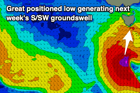
 Of greater importance though is a strong low that's forecast to develop south of us Sunday evening, with a fetch of severe-gale to storm-force S/SW winds expected to be projected up towards us.
A moderate to large S/SW groundswell is now on the cards, building strongly later Monday, peaking overnight and easing Tuesday.
Building surf to 4ft is likely by dark Monday, easing from 4-5ft Tuesday morning. Winds will be onshore and out of the SW on Monday in the wake of the low, W/SW on Tuesday favouring protected spots.
Cleaner conditions are due Wednesday at Clifton as the S'ly swell drops further from 3ft, slow easing due to a persistent fetch of polar S'ly gales in our swell window early next week.
Longer term we've got a couple of long-range W/SW groundswells and possible close-range SW swell on the cards, but more on this Monday. Have a great weekend!

