Clean conditions and tricky west swells
Southern Tasmania Surf Forecast by Craig Brokensha (issued Friday 19th July)
Best Days: Saturday, Tuesday afternoon, Wednesday, Thursday morning, Friday
Recap
A good new swell yesterday as conditions improved through the morning, clean into the afternoon and this morning it’s smaller but a new W/SW swell is due into this afternoon.
Today’s Forecaster Notes are brought to you by Rip Curl
This weekend and next week (Jul 20 – 26)
These notes will be brief as Ben's on annual leave.
An increase in W/SW swell expected this afternoon should kick to a small 2ft across Clifton, and ease from a similar size tomorrow along with N’ly winds, favouring more exposed breaks.
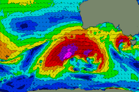
The surf will then be tiny until we see a strong new long-period W/SW groundswell filling in Tuesday and peaking later in the day, easing Wednesday.
 This will be generated by a significant frontal progression developing south-west of WA and moving under the country over the coming days.
Winds will reach the storm-force range but the northern positioned of the progression will just be within our swell window (right) and as a result the swell will be very west in nature.
The long-period nature though should help the swell get in, with Tuesday starting tiny ahead of an inconsistent pulse to 2ft to possibly 3ft at magnets later in the day, easing from a similar size Wednesday morning.
Conditions will be great with persistent N/NW winds Tuesday and NW-N/NW winds Wednesday as the swell eases.
Longer term we may see a better W/SW groundswell later week, but more on this Monday. Have a great weekend!

