Large windy swells on the way
Southern Tasmania Surf Forecast by Craig Brokensha (issued Wednesday 24th April)
Best Days: Thursday, protected spots Friday afternoon through Saturday, Monday
Recap
Tiny waves the last couple of days, but some new W/SW swell should be on the build now with Cape Sorell showing a good rising trend.
Today’s Forecaster Notes are brought to you by Rip Curl
This week and weekend (Apr 25 – May 3)
Today's building swell, generated by a strengthening front moving in from the west yesterday will be reinforced by another good W/SW groundswell tomorrow, produced by a slightly stronger though more zonal front that's currently west of us and will pass under the state early tomorrow morning.
2-3ft surf is due across Clifton, much bigger at exposed west facing locations along with a fresh W/NW breeze, possibly tending NW for a period during the day.
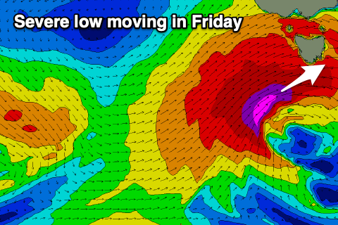
 Of greater significance is the severe low that's forecast to form south of Western Australia this evening. The models are still consistent with their forecasts of a severe-gale to storm-force W/SW fetch to be projected east through our western swell window, with the low moving across us Friday, followed by a trailing SW fetch into Friday afternoon and evening.
We'll see a rapid jump in large long-period W/SW groundswell through Friday from later morning/midday with Clifton likely to reach an easy 6ft if not more by dark. The swell will have lots of west in it though so don't expect too much in protected spots, if anything at all.
Saturday morning will have a bit more SW in the swell direction as the swell eases from 4-5ft or so.
A reinforcing W/SW swell should be seen into Sunday, generated by a secondary strengthening frontal system swinging in from the west on Saturday, producing a fetch of W/SW gales below us.
This will keep Clifton around 4ft or so Sunday morning, easing slowly into the afternoon and smaller from 2-3ft Monday.
Coming back to the expected winds and Friday will be tricky with strong W-W/NW tending W/SW winds, similar Sunday with fresh to strong W-W/NW winds.
Sunday looks average in the wake of the front with W/SW breezes, much better Monday with a weaker W/NW offshore.

