Lots of varying swell pulses to come
Southern Tasmania Surf Forecast by Craig Brokensha (issued Friday 15th February)
Best Days: Saturday morning, Sunday morning, protected spots early Tuesday, Wednesday morning
Recap
Yesterday's reinforcing swell came in at a good 2-3ft across Clifton, easing off from a smaller 1-2ft this morning with light offshore winds, better than expected.
Today’s Forecaster Notes are brought to you by Rip Curl
This week and next (Feb 16 - 22)
We'll fall in between swells tomorrow but the coast shouldn't go flat with 1-1.5ft surf expected for beginners, if not for the odd sneaky 2ft set.
Later in the day and more so Sunday a new S/SW swell should keep sets up around 2ft, generated by a weak polar front that's currently weakening south of us.
 Conditions will be nice tomorrow morning with a N/NW offshore ahead of S/SE sea breezes, light N Sunday, tending NE and then more E/SE.
A low point in swell is due Monday, but our new W/SW swell for Tuesday has changed a little.
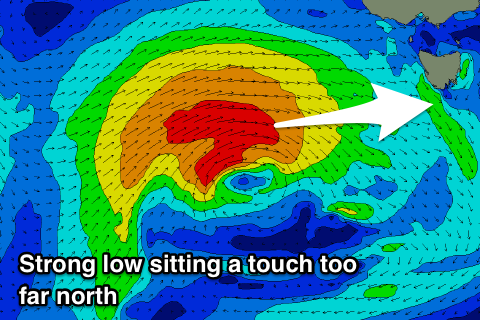
The slow moving low linked to it is still on track, but it will sit just a tad too far north of our swell window now and generate a fetch of W'ly gales right on the edge of it.
This will give the swell a very acute westerly angle and as a result we can expect a drop in consistency and size.
The swell is due to peak Tuesday morning and with the front maintaining its strength as it passes under us Monday afternoon and evening, we should still see 2-3ft sets across Clifton, easing through the day and down from 1ft to maybe 2ft Wednesday.
Winds Tuesday look suss with the front being so close resulting in W tending W/SW breezes, and SW into the afternoon.
Longer term some new long-range and small W/SW groundswell is due late week, but more on this Monday. Have a great weekend!

