Fun swell to end off the week with plenty more surf days to come
Southern Tasmania Surf Forecast by Craig Brokensha (issued Wednesday 13th February)
Best Days: Thursday, Sunday morning, Tuesday, Wednsday morning
Recap
Tiny surf yesterday with 1-1.5ft waves on the coast, but today our solid increase in short-range W/SW swell came in on forecast with clean 3ft sets across Clifton.
Today’s Forecaster Notes are brought to you by Rip Curl
This week and next (Feb 14 - 22)
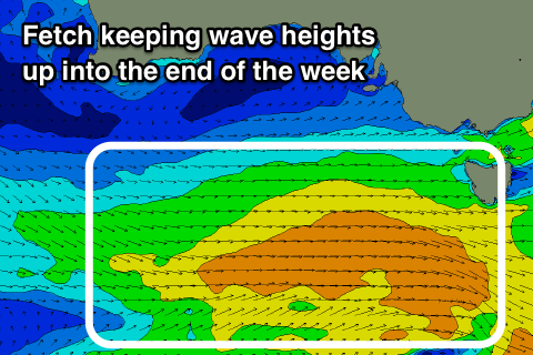
Today's swell is expected to ease off through tomorrow, but a front strengthening and moving in from the west currently towards the state will generate a good elongated fetch of strong W'ly winds through our western swell window.
We should see the swell from this front filling in tomorrow afternoon and kicking back to 2ft+ across Clifton. The morning may be a touch undersized.
 Conditions should be clean through the morning with a W/NW-NW offshore, more W/NW into the afternoon, while Friday looks average as the swell eases from the 2ft range with a W-W/SW breeze, tending more onshore through the day.
Our new S/SW swell for Sunday is still on track, with a polar front due to generate a good fetch of strong W/SW winds to the south of us tomorrow.
We should see fun 2ft sets out of the S/SW and with a morning N/NW offshore ahead of SE sea breezes.
Our next increase in swell is due out of the W/SW as a slow moving and relatively weak low forming south-west of WA moves closer to us early next week, generating a fetch of strong W/SW winds right towards us.
The slow moving nature of the front should produce a moderate sized W/SW swell, peaking to a good 2-3ft across Clifton Tuesday with NW offshores. Follow up fronts look to generate another similar if not slight smaller pulse late week but with poor winds. More on this Friday.


Comments
Hi Craig, what swell size would you expect for Saturday morning?
Looks like we'll be in between swells. Probably 1-1.5ft if not for the stray 2ft'er. Not flat.
Thanks
There was a time ol Hori would just drive down for a look.....
Haha
Yeah. Still does a lot of driving!
Not at all how it use to be either though so hardly worth the frive!
Craig, maybe you could investigate for us South Eastern Tasmanians saying the same thing:
- Certain Southern Point breaks are non existent, sure we've had some 2-3 ft ones but it will be 8 years straight this year if we don't get a solid point swell, the ones that obliterated the beaches on a yearly basis leaving deep gutters for the rest. Then there is the once quite semi consistent Rivermouth break thst is now pretty much an age old phantom.
For the South anyway it seems once we get a big good looking Low a big fucking fuck off High pushes it down........
When you say non-existent you mean haven't broken in a long time? I know the river mouth break, but at the same time the Southern NSW coast has had a lean few years as well with no large quality south-east to east swell.
Yeah that's it. 8 years since there's been an absolute thumping from the Southern Ocean and the Rivermouth is seemingly non existent. I know about the Southern NSW Coast being quiet too but it's not just lack of E-SE swells but solid NE swells too. Why is this?
As for the former, I did read something a year or so ago that a Senior Oceanographer/Meteorologist wrote which read along the lines of that the jetstreams had pushed the roaring 40s down towards more Southern latitudes into the roaring 50s zone. This puts Tassie in the roaring 30s and Victoria the 30s?!!
So instead of the big winter cold fronts sweeping up over Tassies Southcoast, leaving My Wellington absolutely blanketed in snow and solid pointbreak surf, they skip further South missing land completely.
You can see this in the Synoptics - A filthy great low pressure system is 9.5 times pushed out of the way by a big fucking fuck off out of it High pressure system..... Time and time agzin. Everyone says it's not like it use to be.
I'm just trying to make sense of it all which is why I've probably answered some of my question already but I am digging deeper as to why???!
So true SGAG.