Pulsey westerly swells followed by more southerly energy on the weekend
Southern Tasmania Surf Forecast by Craig Brokensha (issued Monday 11th February)
Best Days: Tuesday, Wednesday morning, Thursday, Saturday, Sunday
Recap
Nothing for experienced surfers to get moving on over the weekend, best for beginners yesterday and today.
Today’s Forecaster Notes are brought to you by Rip Curl
This week and weekend (Feb 12 - 17)
We should see a slightly better pulse of W/SW groundswell tomorrow morning across Clifton, generated by a polar fetch of W/SW gales south-southwest of WA Friday evening and Saturday morning. Inconsistent 2ft sets are due across Clifton.
A moderate to fresh N'ly wind is expected to swing strong W/NW through the day as a vigorous frontal system moves across us, strengthening while forming a deep low pressure centre.
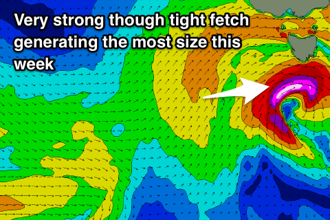
 This low will stall slightly south of us Tuesday evening, aiming severe-gale to storm-force W/SW-SW winds through our swell window. This is expected to produce a spike in localised swell Wednesday morning to 2-3ft across Clifton. W/NW winds should create clean conditions through the morning, shifting W/SW through the day.
The swell should ease back from 2ft on Thursday morning, but another weaker front strengthening while moving in and across us on Wednesday should produce a reinforcing W/SW swell for Thursday afternoon and Friday morning, maintaining 2ft surf.
Winds on Thursday should hold out of the W/NW for most of the day, with Friday unfortunately looking dicey as an early onshore change moves through.
A small fetch of strong polar W/SW winds on the back of all the polar frontal activity is due to generate a reinforcing S/SW swell for later Saturday and more so Sunday morning to a small 2ft and with a morning offshore. There may be a S'ly pulse ahead of this Saturday morning from polar S'ly gales, but we'll review this Wednesday.
Longer term a stalling low south of WA through the weekend will generate an acute W'ly swell for early next week, but more on this Wednesday.

