Small improving swells through next week
Southern Tasmania Surf Forecast by Craig Brokensha (issued Friday 8th February)
Best Days: Beginners Sunday, Monday, Tuesday, Wednesday, Thursday
Recap
Tiny bumpy waves yesterday, cleaner this morning but tiny again.
Today’s Forecaster Notes are brought to you by Rip Curl
This week and weekend (Feb 9 - 15)
The weekend's swell potential has been downgraded a little with the frontal system linked to a small increase in swell now due to push north of our swell window.
As a result tomorrow will most likely remain tiny, with possible 1-1.5ft sets Sunday with a NW tending W breeze, ideal for beginners in the morning.
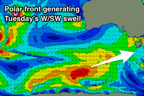
 A slightly better aligned polar front developing south-southwest of WA this evening will generate a fetch of strong to gale-force W/SW winds in our far swell window before projecting north-east and too far north again.
An inconsistent W/SW swell should be generated, arriving Tuesday morning and offering 2ft sets across Clifton under a gusty NW wind, strengthening from the W/NW and holding into the afternoon. Before this on Monday Clifton will likely see 1-2ft of background W/SW swell from strong W/SW winds spread out between us and the front.
Tuesday's strengthening W/NW wind will be linked to a strong storm pushing across the south-east of the country, but again all the action will be mostly too north for us.
On the backside of the storm though we should see a better aligned fetch of strong W/SW winds moving in slowly from the west.
With this we'll hopefully see some better W/SW swell to 2ft+ or so, but we'll have to look at this again on Monday as the structure and alignment of this system are crucial. Have a great weekend!

