Average end to the week, better from the weekend
Southern Tasmania Surf Forecast by Craig Brokensha (issued Wednesday 6th February)
Best Days: Sunday, Monday, Tuesday morning, early Wednesday
Recap
Onshore winds and not much in the way of surf yesterday, cleaner this morning though only 1-1.5ft.
Today’s Forecaster Notes are brought to you by Rip Curl
This week and weekend (Feb 7 - 10)
There's nothing significant due into the end of the week, though the East Coast should offer fun options, while a front moving across us Friday will only produce a tiny W/SW windswell.
We then look at the relatively weak polar front moving in through our swell window over the coming days from the South West of WA.
Wind speeds will only be strong and the front will project up towards Victoria out of our swell window and across us Saturday.
A small mid-period W/SW swell is due off this front, building later Saturday and peaking Sunday. Clifton should build to 1-2ft, with Sunday seeing more consistent waves to 2ft.
 Winds Saturday look dicey with a dawn N/NW offshore giving into a mid-morning W/SW change as the front moves through.
Sunday will be better with a NW offshore, W/NW into the afternoon.
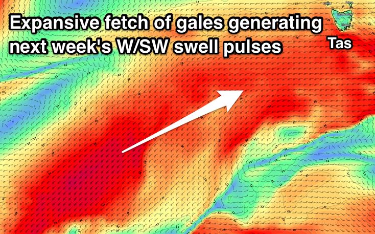
We've got better swell producing frontal activity into early next week, with an elongated fetch of strong to gale-force W/SW winds due to develop from our state to the polar shelf, south-west of WA from Saturday evening through Sunday, before a polar front projects S/SW winds up and towards South Aus, out of our swell window.
Fun levels of W/SW swell should be seen from Monday, the first building to 2-3ft across Clifton, and holding Tuesday, easing from a similar size Wednesday.
Winds should be good and offshore from the N/NW-NW Monday, N'th Tuesday ahead of an afternoon W'ly change and then W/NW to W/SW Wednesday. More on all of this Friday though.

