Easing surf with a new mix of swells for the weekend
Southern Tasmania Surf Forecast by Craig Brokensha (issued Monday 21st January)
Best Days: Tuesday morning, Thursday morning, Friday early afternoon, Sunday
Recap
A tiny weekend of surf, but our strong new W/SW groundswell for today has come in as expected to 3-4ft sets across Clifton with a morning offshore, giving into afternoon S'ly sea breezes.
Today’s Forecaster Notes are brought to you by Rip Curl
This week and weekend (Jan 22 - 27)
The groundswell should be easing across the coast this afternoon and we'll see it dropping further tomorrow from 2ft at Clifton with a light NW offshore ahead of SE sea breezes.
Come Wednesday a small weak mid-period SW swell is due to fill in, generated by a weak front projecting up and into us. As a result winds will go onshore out of the S/SW with small weak waves to 2ft expected.
 Thursday should be cleaner with a N/NE offshore, favouring selected breaks as the swell eases from 1-2ft.
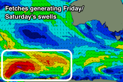
Moving into Friday and a new SW swell should fill in, produced by a polar fetch of pre-frontal W/NW winds ahead of a better and stronger fetch of W/SW gales.
The W/NW fetch should produce 1-2ft of SW swell for Friday afternoon under a N'ly tending W/NW breeze, while the stronger groundswell component should fill in on Saturday and reach 2ft+ into the afternoon.
Also in the mix will be a sneaky S/SE groundswell from a tight but persistent and strong polar fetch of severe-gale to storm-force S/SE winds.
Inconsistent but good 2-3ft sets are due to build through Saturday, easing from a similar size Sunday morning.
Winds on Saturday look dicey and from the W/SW tending S/SE with a weak front moving through, while Sunday looks good with a N/NW tending W/NW breeze.
Into next week a strong mid-latitude front pushing across us may bring some small W'ly windswell but more on this Wednesday.

