Generally tiny swells best for beginners
Southern Tasmania Surf Forecast by Craig Brokensha (issued Friday 11th January)
Best Days: Tuesday morning
Recap
Small fun amounts of W/SW swell yesterday, back to a tiny 1-1.5ft today and bumpy across Clifton with winds from the eastern quadrant.
Today’s Forecaster Notes are brought to you by Rip Curl
This week and weekend (Jan 12 - 18)
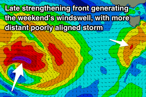
The weekend looks void of any decent surf, with tiny waves due tomorrow morning with a dawn N/NW breeze due to give into a strong W/SW change by mid-morning.
This change will be linked to a weak front pushing across us, with a tiny increase in bumpy W/SW windswell likely later in the day to 1-1.5ft, fading from 1ft Sunday with an offshore NW breeze.
 Monday looks tiny to flat, while into Tuesday morning a tiny and acute W'ly groundswell may be seen.
This swell will be generated by a poorly aligned and distant storm that's currently forming west-southwest of WA.
A tight fetch of gale to severe-gale W'ly winds will dip east-southeast through our western swell window, generating a small to tiny W'ly groundswell. We may see 1-1.5ft sets Tuesday morning with a N/NW offshore before SE sea breezes kick in.
Following this the weak polar frontal activity that was expected to follow looks very minimal now and we're not expecting anything of size with tiny surf continuing across Clifton.
The East Coast outlook is also unfortunately fairly poor with no options over that side of the state.
Have a great weekend and check back here Monday for any change to next week.

