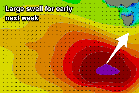
Large swell inbound early next week
Southern Tasmania Surf Forecast by Craig Brokensha (issued Friday 4th January)
Best Days: Sunday morning, Monday afternoon, Tuesday morning, Wednesday morning
Recap
Our strong SW swell peaked at a great 3-4ft across Clifton yesterday morning with good winds, easing steadily through the day and down to 1-1.5ft this morning.
Today’s Forecaster Notes are brought to you by Rip Curl
This week and weekend (Jan 5 - 11)
Tomorrow's W'ly swell is looking even more favourable today, with the intense mid-latitude low expected to maintain its strength for longer than forecast on Wednesday.
It's currently west of us and generating a fetch of W'ly gales, but will move under us and further east-southeast through this evening and tomorrow.
A good pulse of W'ly swell should be seen through the day tomorrow, building to 2ft into the afternoon (tiny most of the morning), easing from 2ft Sunday morning.
Winds tomorrow afternoon will swing more W'ly so with the west swell, conditions will be hit and miss, while Sunday looks best to me with a W/NW-NW offshore, tending W/SW late.
We're had a change in the timing and upgrade in size of the SW groundswell due early next week across the state.
 A vigorous polar low will form south of WA this evening, with a great fetch of severe-gale to possibly storm-force W/SW winds being projected slowly east through our swell window.
The storm will only lose a touch of strength while passing under us Sunday evening and early Monday.
A large long-period SW groundswell should be seen, building rapidly through Monday and peaking later in the day to 4-5ft, easing from 3-4ft Tuesday morning.
Winds will be onshore and sea breezey Monday afternoon, while Tuesday looks excellent with a N/NE offshore ahead of sea breezes.
Longer term smaller swells are on the cards for the rest of next week, but more on this Monday. Have a great weekend!

