Much more active period
Southern Tasmania Surf Forecast by Craig Brokensha (issued Friday 28th December)
Best Days: Saturday morning, early Sunday, Monday morning, Tuesday morning, Wednesday morning, Thursday
Recap
Tiny leftovers yesterday, with onshore and near flat conditions today.
Today’s Forecaster Notes are brought to you by Rip Curl
This weekend and next week (Dec 29 – Jan 3)
A little more action is due over the weekend as a couple of strengthening mid-latitude fronts moving in from the west generate better fetches in our swell window.
Tomorrow a little pulse of W/SW swell is due from a less than favourably aligned but strengthening front west-southwest of us Wednesday and Thursday.
 1-1.5ft surf is mostly due with the possibility of the odd 2ft'er, but of greater importance is the next system that's inbound.
This is currently too north of our swell window but will dip east-southeast through this evening and tomorrow and produce a burst of W/SW gales through our western swell window.
While looking good on paper the system will move quickly south-east and the fetch will be limited in our swell window. I've wound back the expectations slightly from this system to 2ft+ across Clifton Sunday morning, easing quickly through the day.
Conditions will be clean tomorrow morning with a NW offshore, giving into a W/SW and then SW change, while Sunday looks a little dicey but we'll hopefully see early variable winds, ahead of SE breezes mid-late morning.
Another mid-latitude front pushing in right on the edge of our swell window tomorrow and Sunday is due to produce a fetch of strong to gale-force W'ly winds.
A new pulse of W'ly swell is expected to fill in Monday, kicking to 2ft during the day across Clifton, likely undersized early.
A N/NW offshore is due to give into SE sea breeze, so try and surf late morning before the wind gets into it.
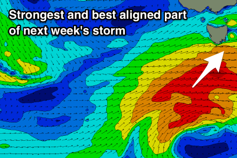
A much stronger, broader and more significant frontal progression is due to move in early next week, with a great fetch of gale to severe-gale W/SW winds being generated initially west-southwest of us before the storm moves under us with the fetch becoming better aligned in our south-western swell window.
We should see a good increase in W/SW swell through Wednesday ahead of a better SW groundswell for Thursday morning.
Size wise we're looking at building sets to 3ft on Wednesday out of the W/SW, easing from 3ft Thursday from the SW.
An early W/NW breeze is likely Wednesday morning, tending W/SW mid-morning as the swell builds, while Thursday looks great with a N/NW tending NE breeze. We'll confirm this on Monday though. Have a great weekend!

