Tiny swells until next week
Southern Tasmania Surf Forecast by Craig Brokensha (issued Wednesday 19th December)
Best Days: Monday late morning onwards, Tuesday morning, Wednesday morning
Recap
A poor onshore but surfable S/SE windswell yesterday, much cleaner this morning and hanging in with a bit more size than expected offering fun conditions.
Today’s Forecaster Notes are brought to you by Rip Curl
This week and next week (Dec 20 - 28)
Our current SE swell will drop right back into tomorrow leaving tiny surf on the coast, and a slight lift in W/SW swell for Friday doesn't look to top 1ft+. Conditions will be poor in any case with a fresh onshore wind.
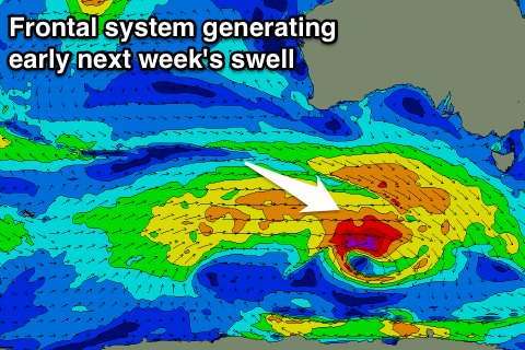
We then look to next week, when a strengthening frontal system moves in from the west-southwest during the weekend.
 This storm isn't looking as broad or as strong as forecast on Monday and the models keep downgrading it with each update, which isn't a good sign.
Instead we're now looking at a fast and tight moving fetch of gale to severe-gale W/SW winds through our south-western swell window, producing a small new SW swell for Monday, building to 2-3ft into the afternoon, easing back from 2ft Tuesday.
Conditions are looking good Monday with all day offshore NW winds, and then NW tending W/SW on Tuesday. We may see a reinforcing SW swell Wednesday from a secondary weaker but broader frontal system, though we'll review this Friday.

