Good swells early next week
Southern Tasmania Surf Forecast by Craig Brokensha (issued Friday 30th November)
Best Days: Beginners Saturday, Monday, Tuesday, Wednesday morning
Recap
Average surf again yesterday while today there's a tiny new W/SW swell out on the coast best for beginners.
Today’s Forecaster Notes are brought to you by Rip Curl
This weekend and next week (Dec 1 - 7)
Tiny surf will continue tomorrow as a new W'ly swell fills in, generated by a stronger but less favourably aligned frontal system earlier this week.
1-1.5ft sets are due with a N/NW tending gusty N'ly wind.
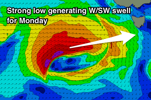
A low point in swell is due on Sunday morning but into the afternoon we should start to see some new W/SW swell building, peaking Monday morning ahead of a secondary pulse of swell for the afternoon, easing Tuesday.
 Later Sunday and Monday morning's swell will be generated by an intense low that's formed south-west of WA.
A fetch of severe-gale W'ly winds will be generated too far north of our swell window before the low nears us over the weekend, dropping slightly east-southeast and more into our swell window.
This should produce a moderate sized W/SW groundswell that should show late Sunday but peak Monday morning to a good 3ft on the sets across Clifton.
A secondary front spawning off the back of the low will project into us on Monday though, with a fetch of W/SW gales pushed up and across the state.
This will generate a reinforcing W/SW swell for late in the day and Tuesday morning, easing back from 2-3ft.
Winds on Monday will be accordingly fresh and gusty out of the W/NW most of the day ahead of a late afternoon change, back to the W/NW for most of Tuesday.
The swell will continue to ease into the end of the week with nothing significant at all on the cards for our region. Therefore make the most of the windows of swell and clean conditions early next week. Have a great weekend!

