Strong swell tomorrow, with fun waves the rest of the week
Southern Tasmania Surf Forecast by Craig Brokensha (issued Monday 5th November)
Best Days:
Recap
Large building bumpy surf through Saturday, clean and pumping on Sunday morning with easing 4-5ft sets with a moderate offshore wind.
This morning the swell was smaller and more manageable but still super fun.
Today’s Forecaster Notes are brought to you by Rip Curl
This week and weekend (Nov 6 - 11)
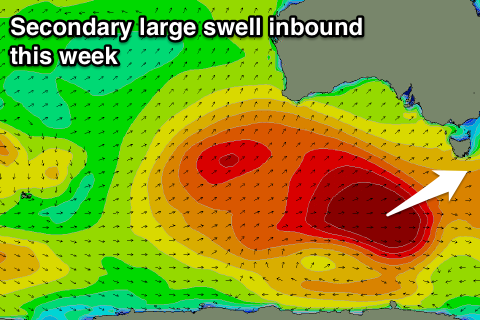
Our secondary strong long-period W/SW groundswell for tomorrow is still on track, with an intense polar low forming south-west of WA later last week, generating a fetch of severe-gale to storm-force W/SW winds in our swell window over the weekend.
The low is currently weakening south-west of us and we'll see the groundswell arriving tomorrow and peaking through the day to a solid 3-4ft across Clifton, if not for the odd bigger bomb.
Winds look great through the morning with a N/NW offshore, giving into a shallow W/SW change and possibly swinging back NW late.
 The swell is expected to ease into Wednesday from 2-3ft with a fresh W/NW offshore expected to hold most of the day ahead of a W/SW change mid-late afternoon.
This change will be linked to a broad but relatively weak polar front pushing under us, with it forming on the back of the strong low linked to tomorrow's groundswell.
This should generate a fun mid-period W/SW swell for Thursday to 2-3ft across Clifton, easing back from 2ft or so Friday.
Winds look mostly onshore Thursday aside from an early W/NW breeze, with better NW offshores Friday, tending W/NW and then possibly variable.
The weekend isn't looking too flash with clean though tiny fading surf, though we may see a new swell for early next week. We'll have to review this on Wednesday.

