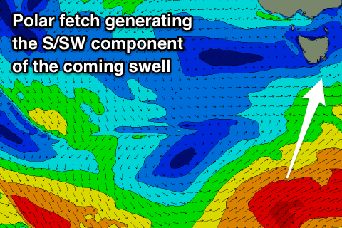
Fun waves over the coming days working the winds
Southern Tasmania Surf Forecast by Craig Brokensha (issued Wednesday 10th October)
Best Days: Thursday morning, Friday before winds go east, Saturday selected spots
Recap
Small clean 1-2ft waves yesterday morning before an onshore change moved through, with junky 2-3ft of windswell today with fresh S'ly winds.
Today’s Forecaster Notes are brought to you by Rip Curl
This week and weekend (Oct 11 – 19)
The polar front and strong high moving in from the west, linked to yesterday's change and today's windswell will move slowly east tomorrow, resulting in a more favourable morning W/NW offshore and easing mix of swells from 2ft.
Winds are due to swing onshore by late morning, so get in a surf before then.
 Our new long-period SW groundswell for Friday is still on track, with the initial stages of the tight and intense polar low not being great, though currently a good fetch of W/SW gales are being generated through our southern swell window, and will continue to do so this evening before the front pushes further east tomorrow morning.
A good SW tending S/SW groundswell should fill in Friday and reach 3ft across Clifton likely through the afternoon with a light N/NW breeze, tending NE through the morning and fresher E/NE through the afternoon.
Saturday looks fun as the swell eases back from 2ft+ with N tending N/NE winds.
Into Sunday the swell will continue to ease leaving tiny waves for beginners with a fresher N/NE wind, and from here there's nothing significant on the cards until mid-late next week owing to the blocking high preventing any major storms to develop in our swell windows.
Mid-late next week's swell isn't too great either, generated by a distant mid-latitude storm south-west of, limiting the size and consistency back to the small to tiny range. More on this Friday.

