Easing surf ahead of an increase in activity from later Friday
Southern Tasmania Surf Forecast by Craig Brokensha (issued Monday 10th September)
Best Days: Tuesday, later Friday, Sunday
Recap
Tiny all weekend, while today our new W/SW groundswell has filled in, 2ft this morning with sets expected to reach 2-3ft into this afternoon.
Today’s Forecaster Notes are brought to you by Rip Curl
This week and weekend (Sep 11 - 16)
Our reinforcing SW swell for tomorrow morning is still on track, though with a slight downgrade in size from Friday.
A tail fetch of south-east tracking severe-gale W'ly winds on the back of the storm generating today's swell should keep 2ft sets hitting Clifton tomorrow morning, fading into the afternoon and tiny Wednesday.
Winds will be best early tomorrow for Clifton with a N/NW offshore, gusty from the N'th into the afternoon.
For the rest of the week there's nothing major on the cards until later Friday, with a weakening mid-latitude front dipping south-east across us Wednesday not likely to bring any swell with it.
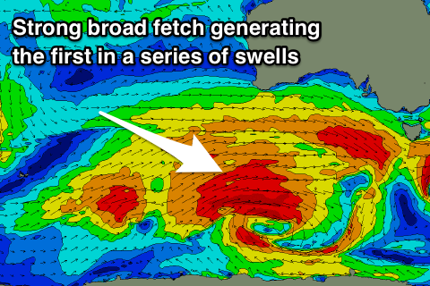
 Into Friday afternoon and more so the weekend we're looking at a broad and elongated polar frontal progression developing in the south-east Indian Ocean and pushing east under the country.
An initial fetch of W'ly tending W/NW gales will produce a tiny acute W'ly groundswell for Friday morning but with no size above 1ft.
A much better aligned and stronger polar fetch of slow moving W/SW gales should project east through our far western swell window tomorrow afternoon and Wednesday, stalling south of WA on Thursday while weakening.
This will generate a good new W/SW groundswell for later Friday and more so Saturday, building to 2ft across Clifton and coming in at 3ft on the sets Saturday morning with what looks to be poor W/SW winds as a secondary strong front pushes across us.
While bringing onshore winds on Saturday, it will also bring a further increase in W/SW swell later in the day and Sunday morning more to 3-4ft on the sets.
Winds look to improve all day Sunday as another front approaches from the west, tipping them from W/NW to NW into the afternoon.
We'll confirm this on Wednesday though.
Longer term the storm track will push too far north of us generating smaller W/SW swells, but more on this Wednesday.


Comments
Today had a few small runners down on the arm but very inconsistent & long waits for what did come through.... 2/3 foot was a bit over rated more like 1 occasionally 2 foot. Will tomorrow morning be similar to today or a bit bigger & more consistent ?
I'd say a little more consistent and better direction.
Thanks Craig
How'd ya go? Sounded fun.