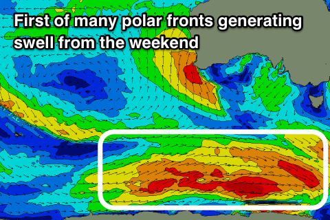
Plenty of swell this period, especially from the weekend
Southern Tasmania Surf Forecast by Craig Brokensha (issued Monday 27th August)
Best Days: Wednesday and Thursday mornings, Saturday, Sunday protected spots, Monday morning
Recap
Our good pulse of SW groundswell expected on Saturday came in at a strong 3-4ft across Clifton, easing into Sunday with favourable conditions again.
This morning the swell lifted again but with poor onshore winds.
Today’s Forecaster Notes are brought to you by Rip Curl
This week and weekend (Aug 28 – Sep 2)
Our current mix of swells are due to ease back tomorrow, with 2ft waves across Clifton along with dicey winds. There's an outside chance for an early light W'ly wind, but we're more than likely to see S/SE winds across the region.
A strong Tasman Low forming to our east-southeast looks to be positioned a touch too far north to generate any sizey SE swell for Clifton, though further down the Arm you'll see some good E/SE groundswell getting in Wednesday.
Winds look as if they'll be light W/NW offshore through the morning, swinging S/SE into the afternoon.
Size wise we're not looking at too much above 1-2ft out of the SE across Clifton, fading through Thursday, mixed in with a long-range W/SW groundswell to 2ft. This groundswell was generated by a strong polar low forming east of Heard Island through the weekend.
Of greater importance is the succession of strong polar fronts firing up mid-late week through the Southern Ocean.
 The first will generate a fetch of polar W/NW tending W and then W/SW gales through our south-western swell window, weakening just south-southwest of us on Thursday evening.
The groundswell is due to arrive overnight Friday and peak Saturday to a fun 2-3ft across Clifton. Winds are a little dicey but we're looking at a morning W/NW breeze, likely holding all day as a secondary front fires up towards us.
This secondary front will project a fetch of broader W/SW tending SW gales through our western and then south-western swell window on the weekend, passing across us Sunday.
This will result in strong onshore SW winds and building levels of SW swell to 4-5ft or so at this stage.
Monday is looking much better as the swell eases with a morning W/NW breeze, onshore into the afternoon.
Longer term there is lots of follow up frontal activity, but more on this Wednesday.

