Fun swell pulses through the coming period
Southern Tasmania Surf Forecast by Craig Brokensha (issued Friday 17th August)
Best Days: Beginners Saturday morning, Monday morning, Wednesday
Recap
Fun waves the last couple of days with a new swell pulse yesterday to 2ft, while today's S/SW swell has kept the surf around 2ft at Clifton.
Today’s Forecaster Notes are brought to you by Rip Curl
This weekend and next week (Aug 18 – 24)
We'll see the surf ease back through tomorrow and be best for beginners, as today's S/SW swell drops away from 1-1.5ft with a W/NW tending W breeze.
Moving into Sunday we're still expected to see the strong mid-latitude low push across us, bringing poor onshore S/SW winds and a building S'ly windswell likely to a junky 3-4ft.
 The low will continue off to the north-east on Monday and with this we'll see a rapid drop in size with easing 2-3ft sets under a NW offshore as another front quickly moves in from the west.
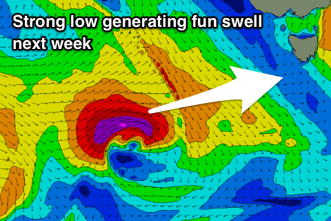
This low has been upgraded a little in strength but will be short-lived with a burst of severe-gale to storm-force W/SW winds expected through our western swell window Sunday and Monday.
The swell should kick strongly Tuesday afternoon and reach 2-3ft before dark but winds will be onshore out of the W/SW, after an early W/NW breeze.
Wednesday will be nice and clean as the swell eases from 2ft+ or so.
Longer term we should see some good new W/SW groundswell later week from a broad and elongated polar frontal progression moving in from the west mid-next week. More on this Monday though. Have a great weekend!

