Fun swells to end the week
Southern Tasmania Surf Forecast by Craig Brokensha (issued Wednesday 15th August)
Best Days: Thursday morning, Friday, Saturday morning, Monday
Recap
A continuation of small inconsistent 2ft waves yesterday, similar this morning with long waits for the sets and gusty offshore winds.
Today’s Forecaster Notes are brought to you by Rip Curl
This week and weekend (Aug 16 - 19)
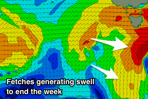
Today's strong winds are linked to a vigorous mid-latitude low pushing across us, with a fetch of strong to gale-force W/NW tending W winds being generated through our western swell window.
No major size is due off this, but a better aligned fetch of strong to gale-force W/SW winds just south of us should produce a small kick to 1-2ft tomorrow.
 Our polar fetch of S/SW winds looks a little shorter-lived in our swell window, but we're still expected to see a fun reinforcing pulse of S/SW swell for Friday with sets to 2ft+ across Clifton, easing into the afternoon and further Saturday from 1-1.5ft.
Winds tomorrow will be gusty our of the W/NW, tending W/SW through the day, with all day offshore N/NW winds on Friday – N/NW tending W/NW Saturday.
The strengthening polar front mentioned in Monday's notes for the weekend now looks to take the form of a cut-off low, and with this we'll see a poor windswelly swell event.
The low is forecast to move across us Sunday, bringing strong S/SE winds and a building S/SE windswell, clean but easing Monday from the 2ft+ range.
We may see a fun new SW groundswell mid-week of a polar low moving in from the west early next week, but we'll look at this again on Friday.

