Slow week, better from the weekend
Southern Tasmania Surf Forecast by Craig Brokensha (issued Monday 6th August)
Best Days: Thursday morning, Sunday and Monday mornings
Recap
Tiny surf most of the weekend ahead of very late pulse of W/SW swell, peaking this morning to a good 2ft across Clifton.
Today’s Forecaster Notes are brought to you by Rip Curl
This week and weekend (Aug 7 - 12)
Want to receive an email when these Forecaster Notes are updated? Then log in here and update your preferences.
I hope you made the most of this morning's small spike in swell as we've got a very average forecast period ahead, with a downgrade in the swell due mid-week discussed below.
As discussed last update, a strong negative Southern Annular Mode signal is resulting in the storm track being too north and out of our swell window.
We'll see one of the fronts dip south-east and across us Wednesday afternoon, producing a very short burst of strong W/SW winds, lasting a max of 12 hours before veering away from us.
 The timing of this front isn't ideal, with any swell due to peak overnight, but in saying that we should 1-1.5ft sets Thursday morning, fading through the day. Conditions will be great with an offshore NW breeze, tending more N/NW through the day.
It'll then become flat into the end of the week and start of the weekend, with a new small W/SW swell due to start building Saturday and fill in more so on Sunday.
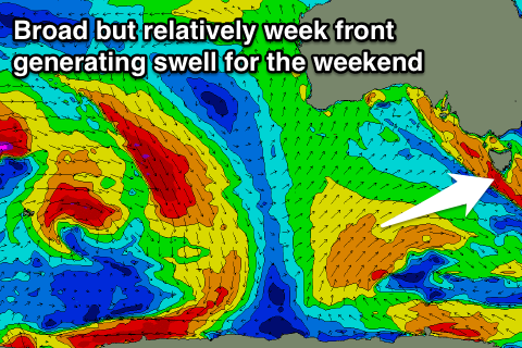
This will be generated by a slow moving and not overly strong but broad polar low, aiming strong to near gale-force W/SW winds through our swell window from Wednesday evening through Saturday morning.
An inconsistent and tiny increase to 1-1.5ft is likely Saturday afternoon with some better size likely Sunday to 1-2ft.
We may see a better front passing over us on Sunday bringing 2ft of swell for next Monday, but we'll review this on Wednesday.

