Fun waves to end out the week
Southern Tasmania Surf Forecast by Craig Brokensha (issued Wednesday 25th July)
Best Days: Thursday, Friday morning, early Saturday
Recap
Nothing of note through yesterday with a flukey long-range W/SW groundswell, but today our new mix of swells has come in a bit better than expected with strong though inconsistent 3ft sets across Clifton.
Today’s Forecaster Notes are brought to you by Rip Curl
This week and weekend (Jul 26 - 29)
Want to receive an email when these Forecaster Notes are updated? Then log in here and update your preferences.
Today's W/SW swell is expected to ease back through tomorrow, but our new W/SW swell has been upgraded a little.
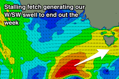
Last night and today a stalling fetch of W/SW gales were generated to our west-southwest, and this front is currently weakening while projecting slightly closer towards us this evening, moving under us tomorrow.
 We should see a good W/SW groundswell building to 3ft through the day, possibly a touch undersized early, easing back from 2ft to maybe 3ft Friday morning.
Conditions should remain clean most of tomorrow in semi-protected spots with a persistent W/NW breeze, and then NW Friday morning, giving into a W/SW change through the afternoon.
This change isn't expected to have much strength behind it resulting in small easing leftover 1ft to maybe 2ft waves Saturday across the coast under NW tending N winds.
A low point in swell is expected Sunday morning, and later in the day some very infrequent long-range W/SW groundswell may be seen, generated by a very significant storm that's currently in the southern Indian Ocean.
We're probably not going to see much above 1-1.5ft later in the day and with a gusty W/SW change as a deepening mid-latitude low moves across us.
We'll likely see an increase in stormy W/SW swell from this low on Monday but with poor winds, cleaning up but dropping rapidly Tuesday. More on this Friday though.

